Woodley, Saskatchewan
Woodley, Saskatchewan | |
|---|---|
 Woodley, Saskatchewan | |
| Coordinates: 49°15′00″N 102°32′24″W / 49.250°N 102.540°W | |
| Country | Canada |
| Province | Saskatchewan |
| Region | Southeast Saskatchewan |
| Census division | 1 |
| Rural Municipality | Benson |
| Government | |
| • Reeve | David Hoffort |
| • Administrator | Laureen Keating |
| • Governing body | Benson No. 35 |
| Area | |
• Total | 0.00 km2 (0.00 sq mi) |
| Elevation | 593 m (1,947 ft) |
| Population (2011) | |
• Total | 0 |
| • Density | 0.0/km2 (0/sq mi) |
| Time zone | CST |
| Area code | 306 |
| [1][2][3][4] | |
Woodley is an unincorporated community in Benson Rural Municipality No. 35, Saskatchewan, Canada. Woodley, like many other small communities throughout Saskatchewan, has struggled to maintain a steady population which made Woodley a ghost town.[5]
Heritage sites
- St Luke's Lutheran church was built in 1929 by Emil Kraus.
See also
References
- ^ National Archives, Archivia Net, Post Offices and Postmasters, archived from the original on October 6, 2006, retrieved January 7, 2013
- ^ Government of Saskatchewan, MRD Home, Municipal Directory System, archived from the original on November 21, 2008
- ^ Canadian Textiles Institute. (2005), CTI Determine your provincial constituency, archived from the original on September 11, 2007, retrieved January 7, 2013
- ^ Commissioner of Canada Elections, Chief Electoral Officer of Canada (2005), Elections Canada On-line
- ^ "Woodley (Saskatchewan)". roadsidethoughts.com. Retrieved July 29, 2024.
Places adjacent to Woodley, Saskatchewan | |
|---|---|
| Cities | 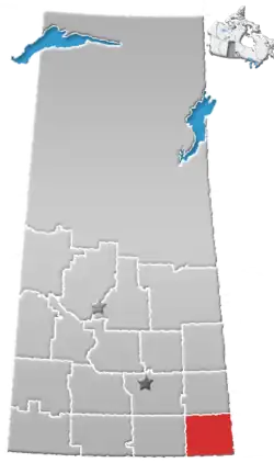 | ||||
|---|---|---|---|---|---|
| Towns | |||||
| Villages | |||||
| Rural municipalities | |||||
| First Nations | |||||
| Indian reserves | |||||
| Unincorporated communities |
| ||||
49°15′00″N 102°32′24″W / 49.250°N 102.540°W