Woodworth, Ohio
Woodworth, Ohio | |
|---|---|
 Location in Mahoning County, Ohio | |
 Woodworth  Woodworth | |
| Coordinates: 40°58′40″N 80°39′17″W / 40.97778°N 80.65472°W | |
| Country | United States |
| State | Ohio |
| County | Mahoning |
| Township | Beaver |
| Area | |
• Total | 3.14 sq mi (8.14 km2) |
| • Land | 3.09 sq mi (7.99 km2) |
| • Water | 0.05 sq mi (0.14 km2) |
| Elevation | 1,125 ft (343 m) |
| Population | |
• Total | 1,784 |
| • Density | 577.91/sq mi (223.15/km2) |
| Time zone | UTC-5 (Eastern (EST)) |
| • Summer (DST) | UTC-4 (EDT) |
| ZIP Codes |
|
| Area codes | 330, 234 |
| FIPS code | 39-86534 |
| GNIS feature ID | 2812829[2] |
Woodworth is an unincorporated community and census-designated place in Beaver Township, Mahoning County, Ohio, United States.[2] The population was 1,784 at the 2020 census.[3] It lies along State Routes 7 and 626, bordering the communities of Boardman to the north and North Lima to the south. It is part of the Youngstown–Warren metropolitan area.
History
Woodworth was originally called Steamtown.[4] A post office called Steamtown was in operation from 1857 until 1860 and a post office called Woodworth from 1874 until 1905.[5]
Demographics
| Census | Pop. | Note | %± |
|---|---|---|---|
| 2020 | 1,784 | — | |
| U.S. Decennial Census[6] | |||
References
- ^ "2024 U.S. Gazetteer Files: Ohio". United States Census Bureau. Retrieved April 16, 2025.
- ^ a b c U.S. Geological Survey Geographic Names Information System: Woodworth, Ohio
- ^ a b "P1. Race – Woodworth CDP, Ohio: 2020 DEC Redistricting Data (PL 94-171)". U.S. Census Bureau. Retrieved April 16, 2025.
- ^ Butler, Joseph Green (1921). History of Youngstown and the Mahoning Valley, Ohio. American Historical Society. p. 587.
- ^ "Mahoning County". Jim Forte Postal History. Retrieved January 18, 2016.
- ^ "Census of Population and Housing". Census.gov. Retrieved June 4, 2016.
Municipalities and communities of Mahoning County, Ohio, United States | ||
|---|---|---|
| Cities | 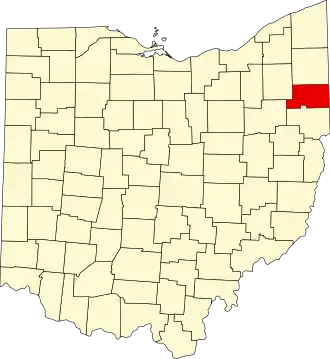 | |
| Villages | ||
| Townships | ||
| CDPs | ||
| Other communities | ||
| Footnotes | ‡This populated place also has portions in an adjacent county or counties | |