Wortel, Belgium
Wortel | |
|---|---|
Village | |
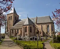 St John the Baptist Church | |
 Wortel Location in Belgium | |
| Coordinates: 51°23′52″N 4°47′45″E / 51.3978°N 4.7958°E | |
| Country | |
| Region | Flemish Region |
| Province | Antwerp |
| Municipality | Hoogstraten |
| Area | |
• Total | 13.54 km2 (5.23 sq mi) |
| Population (2021)[1] | |
• Total | 1,844 |
| • Density | 140/km2 (350/sq mi) |
| Time zone | CET |
| Part of | Colonies of Benevolence |
| Criteria | Cultural: ii, iv |
| Reference | 1555bis-002 |
| Inscription | 2021 (44th Session) |
Wortel is a village in the Belgian municipality of Hoogstraten. As of 2021, it has 1,844 inhabitants.[1]
The toponym means carrot or root in Dutch. Wortel was established in the early 19th century by the Society of Benevolence as a farming colony for the able-bodied working poor. It was meant to provide employment during a time when poverty rates were very high in the Low Countries.[2] Along with the other colonies constructed by the Society of Benevolence, Wortel was inscribed on the UNESCO World Heritage List in 2021 as an excellent example of a unique method of housing reform and urban planning.[2]
Gallery
-
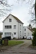 Colony house
 -
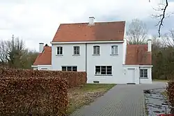 Guard house of the colony
 -
%252C_RP-P-AO-3-62F-1.jpg) Colony map
Colony map -
_-_Pastorijstraat_31_-_Voormalige_pastorie.JPG) Clergy house
Clergy house
References
- ^ a b c "Bevolking per statistische sector - Sector 13014E". Statistics Belgium. Retrieved 9 May 2022.
- ^ a b "Colonies of Benevolence". UNESCO World Heritage Centre. United Nations Educational, Scientific, and Cultural Organization. Retrieved 14 August 2021.
External links
 Media related to Wortel at Wikimedia Commons
- (in Dutch) Official website of Hoogstraten
Belgian municipality Hoogstraten | |
|---|---|
| Deelgemeentes | |
| |