Xirovouni
Xirovouni
Ξηροβούνι | |
|---|---|
 Xirovouni Location within the regional unit 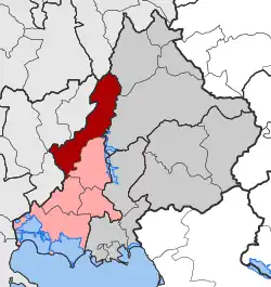 | |
| Coordinates: 39°16′N 20°57′E / 39.267°N 20.950°E | |
| Country | Greece |
| Administrative region | Epirus |
| Regional unit | Arta |
| Municipality | Arta |
| Area | |
| • Municipal unit | 123.634 km2 (47.735 sq mi) |
| Population (2021)[1] | |
| • Municipal unit | 2,854 |
| • Municipal unit density | 23/km2 (60/sq mi) |
| Time zone | UTC+2 (EET) |
| • Summer (DST) | UTC+3 (EEST) |
| Vehicle registration | ΑΤ |
Xirovouni (Greek: Ξηροβούνι) is a former municipality in the Arta regional unit, Epirus, Greece. Since the 2011 local government reform it is part of the municipality Arta, of which it is a municipal unit.[2] The municipal unit has an area of 123.634 km2.[3] Population 2,854 (2021). The seat of the municipality was in Ammotopos.
References
- ^ "Αποτελέσματα Απογραφής Πληθυσμού - Κατοικιών 2021, Μόνιμος Πληθυσμός κατά οικισμό" [Results of the 2021 Population - Housing Census, Permanent population by settlement] (in Greek). Hellenic Statistical Authority. 29 March 2024.
- ^ "ΦΕΚ B 1292/2010, Kallikratis reform municipalities" (in Greek). Government Gazette. p. 17387.
- ^ "Population & housing census 2001 (incl. area and average elevation)" (PDF) (in Greek). National Statistical Service of Greece.