Yanchang County
Yanchang
延长县 Yenchang | |
|---|---|
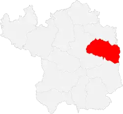 Yanchang in Yan'an | |
.png) Yan'an in Shaanxi | |
| Coordinates (Yanchang County government): 36°34′45″N 110°00′44″E / 36.5793°N 110.0123°E | |
| Country | People's Republic of China |
| Province | Shaanxi |
| Prefecture-level city | Yan'an |
| Area | |
• Total | 2,368.7 km2 (914.6 sq mi) |
| Population (2018) | 158,000 |
| Time zone | UTC+8 (China Standard) |
| Postal code | 717100 |
Yanchang County (simplified Chinese: 延长县; traditional Chinese: 延長縣; pinyin: Yáncháng Xiàn) is a county under the administration of the prefecture-level city of Yan'an, in the northeast of Shaanxi Province, bordering Shanxi Province across the Yellow River to the east. It has a land area of 2,368.7 square kilometres (914.6 sq mi), and a population of 158,000.[1]
Administrative divisions
Yanchang County consists of one subdistrict and seven towns.[1][2] These are then further divided into 159 administrative villages.[1]
Qilicun Subdistrict
Qilucun Subdistrict (七里村街道; Qīlǐcūn Jiēdào) is the county's sole subdistrict.[1][2] Qilicun Subdistrict host's the county's administrative offices.[2]
Towns
Yanchang County contains the following seven towns:[1][2]
- Heijiabao (黑家堡镇; Hēijiābǎo Zhèn)
- Zhengzhuang (郑庄镇; Zhèngzhuāng Zhèn)
- Zhangjiatan (张家滩镇; Zhāngjiātān Zhèn)
- Jiaokou (交口镇; Jiāokǒu Zhèn)
- Luozishan (罗子山镇; Luōzishān Zhèn)
- Leichi (雷赤镇; Léichì Zhèn)
- Angou (安沟镇; Āngōu Zhèn)
Geography
Located on the Loess Plateau,[2] the county's terrain is largely hilly, with a low point of 470.6 metres (1,544 ft) above sea level, and a high point of 1,383 metres (4,537 ft) above sea level.[1] The Yellow River passes through the county, as does the Yan River.[1] The county has a forest coverage of 23%.[1]
Climate
Yanchang County experiences distinctive seasons in regards to both temperature and precipitation.[1] The county has warm and wet summers, and cold and dry winters.[1] The county has an average annual temperature of 10.4 °C (50.7 °F), an average of 2504.6 hours of sunshine per year, and an average of 564 millimetres (22.2 in) of precipitation per year.[1]
| Climate data for Yanchang, elevation 805 m (2,641 ft), (1991−2020 normals, extremes 1981–2010) | |||||||||||||
|---|---|---|---|---|---|---|---|---|---|---|---|---|---|
| Month | Jan | Feb | Mar | Apr | May | Jun | Jul | Aug | Sep | Oct | Nov | Dec | Year |
| Record high °C (°F) | 15.4 (59.7) |
22.4 (72.3) |
29.6 (85.3) |
37.9 (100.2) |
37.5 (99.5) |
41.1 (106.0) |
40.0 (104.0) |
37.3 (99.1) |
38.5 (101.3) |
32.1 (89.8) |
24.2 (75.6) |
18.3 (64.9) |
41.1 (106.0) |
| Mean daily maximum °C (°F) | 3.0 (37.4) |
7.8 (46.0) |
14.6 (58.3) |
22.0 (71.6) |
26.9 (80.4) |
30.6 (87.1) |
31.5 (88.7) |
29.3 (84.7) |
24.4 (75.9) |
18.5 (65.3) |
11.3 (52.3) |
4.5 (40.1) |
18.7 (65.6) |
| Daily mean °C (°F) | −5.6 (21.9) |
−1.0 (30.2) |
5.8 (42.4) |
13.1 (55.6) |
18.2 (64.8) |
22.4 (72.3) |
24.2 (75.6) |
22.4 (72.3) |
17.0 (62.6) |
10.2 (50.4) |
2.9 (37.2) |
−3.9 (25.0) |
10.5 (50.9) |
| Mean daily minimum °C (°F) | −11.3 (11.7) |
−7.0 (19.4) |
−0.9 (30.4) |
5.4 (41.7) |
10.4 (50.7) |
15.2 (59.4) |
18.5 (65.3) |
17.5 (63.5) |
12.2 (54.0) |
5.0 (41.0) |
−2.3 (27.9) |
−9.2 (15.4) |
4.5 (40.0) |
| Record low °C (°F) | −22.3 (−8.1) |
−19.2 (−2.6) |
−15.0 (5.0) |
−7.0 (19.4) |
−0.3 (31.5) |
5.9 (42.6) |
10.3 (50.5) |
8.4 (47.1) |
0.2 (32.4) |
−7.9 (17.8) |
−16.8 (1.8) |
−23.0 (−9.4) |
−23.0 (−9.4) |
| Average precipitation mm (inches) | 3.6 (0.14) |
6.0 (0.24) |
12.8 (0.50) |
24.8 (0.98) |
39.0 (1.54) |
61.4 (2.42) |
113.6 (4.47) |
107.1 (4.22) |
69.3 (2.73) |
40.6 (1.60) |
15.9 (0.63) |
2.5 (0.10) |
496.6 (19.57) |
| Average precipitation days (≥ 0.1 mm) | 2.6 | 2.8 | 4.0 | 6.0 | 7.7 | 9.3 | 11.8 | 11.0 | 9.8 | 8.1 | 4.2 | 1.5 | 78.8 |
| Average snowy days | 3.8 | 3.4 | 1.5 | 0.3 | 0 | 0 | 0 | 0 | 0 | 0 | 1.8 | 2.6 | 13.4 |
| Average relative humidity (%) | 57 | 54 | 53 | 48 | 53 | 59 | 69 | 75 | 76 | 73 | 65 | 60 | 62 |
| Mean monthly sunshine hours | 192.4 | 183.7 | 212.5 | 234.6 | 255.5 | 233.1 | 223.1 | 209.0 | 172.6 | 178.5 | 179.4 | 188.3 | 2,462.7 |
| Percentage possible sunshine | 62 | 60 | 57 | 59 | 58 | 53 | 50 | 50 | 47 | 52 | 59 | 63 | 56 |
| Source: China Meteorological Administration[3][4] | |||||||||||||
History
Human activity in Yanchang County can be traced back thousands of years, and the first administrative district in the area arose in 266 AD.[1]
Qingjian Uprising and Communist insurgency
Communist activity in the area began in January 1927, when a Communist Party branch was set up at a high school in the county.[1] On October 14, 1927, party leaders Tang Shu and Xie Zichang lead an uprising called the Qingjian Uprising, which had failed.[1] However, Communist Party activity in the region continued in subsequent years. In the spring of 1932, a communist uprising in the area occurred yet again, and the Communist Party organized militias afterwards.[1] On May 30, 1935, Communist troops successfully took control of the county.[1] Communist forces would retain control of the county during the rest of the Civil War, as well as during the Japanese Invasion of China.[1]
Economy
As of 2018, the county's GDP was 5.408 billion Yuan, an increase of 8.7% from the previous year.[1] Urban residents had an average disposable income of 34,170 Yuan, and rural residents had an average disposable income of 11,105 Yuan.[1]
Agriculture
The county's main agricultural products are apples, pears, and watermelons.[1]
Mineral Resources
The county has vast deposits, mainly of petroleum, coal, natural gas, and salt.[1][2]
Oil
The county is home to China's first oil well,[1][2] which was constructed on June 5, 1907.[1] During Mao Zedong's rule, oil production in the county was encouraged.[1]
Wangjiachuan Petroleum Drilling Company
In 1985, the county established its own oil company, called Wangjiachuan Petroleum Drilling Company.[1] The company was run by the county government, the first oil company in China to be structured as such.[1][5] The company dug its first well on May 29, 1985, and produced 1,005 tons of crude oil by the end of the year.[5] By the late 1990s, the company's output hovered at around 14,000 tons per year.[5] In 2000, the county government launched reforms meant to boost its productivity, and in 2005 the company had merged into the Yanchang Oilfield Company Ltd.[5]
Present-Day Situation
After merging into Yanchang Oilfield, the county's oil production further expanded, achieving a stable annual output of approximately 250,000 tons from 2005 through 2010.[5] The county now has three oil production plants, which combine for an annual output in excess of 600,000 tons.[1]
Coal
The county has coal reserves of 20.92 million tons.[1]
Natural Gas
The county's natural gas reserves total 2,000 square kilometres (770 sq mi) in area, and 100 billion cubic meters in volume.[5]
Salt
The county's salt reserves total 4.838 billion tons.[1]
Culture
Like other regions of Shaanbei, the county has a rich tradition of paper cutting.[1] Major tourist sites include historic and archaeological sites, red tourism sites, as well as various natural sites, particularly mountains.[1]
Transportation
The county is served by a number of highways, such as Shaanxi Provincial Highway 201 and Shaanxi Provincial Highway 205.[1]
References
- ^ a b c d e f g h i j k l m n o p q r s t u v w x y z aa ab ac ad ae af 延长概况 [Yanchang Overview]. www.ycxc.gov.cn 延长县委宣传部 (in Chinese). Yanchang County People's Government. Archived from the original on 2021-06-05. Retrieved 2021-06-05.
- ^ a b c d e f g 延长县概况地图_行政区划网(区划地名网) (in Chinese (China)). XZQH.org. Retrieved 2020-04-27.
- ^ 中国气象数据网 – WeatherBk Data (in Simplified Chinese). China Meteorological Administration. Retrieved 26 August 2023.
- ^ 中国气象数据网 (in Simplified Chinese). China Meteorological Administration. Retrieved 26 August 2023.
- ^ a b c d e f 延长油田股份有限公司王家川采油厂实现稳产高产_资讯频道_凤凰网. ifeng.com (in Chinese (China)). Retrieved 2020-04-27.