Yellow Line (Rio de Janeiro)
 | |
|---|---|
| Yellow Line Avenida Governador Carlos Lacerda | |
 | |
| Route information | |
| Maintained by Linha Amarela S.A. (LAMSA) | |
| Length | 25 km (16 mi) |
| Existed | 24 November 1997–present |
| Major junctions | |
| West end | Avenida Ayrton Senna in Jacarepaguá |
| East end | |
| Location | |
| Country | Brazil |
| State | Rio de Janeiro |
| Highway system | |
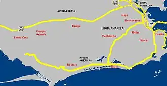
The Yellow Line (Portuguese: Linha Amarela) is an expressway linking Cidade Universitária and Jacarepaguá in Rio de Janeiro, Brazil. The road is officially known as Avenida Governador Carlos Lacerda.[1]
Junctions
The entire route is within the city of Rio de Janeiro.
| Neighbourhood | Exit | Destinations | Notes | |||
|---|---|---|---|---|---|---|
| Jacarepaguá | Avenida Ayrton Senna - Barra da Tijuca, Jacarepaguá | Continues as Avenida Ayrton Senna towards Avenida das Américas | ||||
| 1 | Av. Geremário Dantas - Jacarepaguá, Freguesia, Pechincha, Tanque, Anil, Praça Seca, Grajaú | Eastbound only | ||||
| Freguesia | 1a | Estr. do Pau Ferro - Freguesia, Pechincha, Tanque, Praça Seca, Grajaú | Westbound only | |||
| 1b | Av. Geremário Dantas - Freguesia | Westbound only | ||||
| Méier | 2 | Eastbound: Méier, Engenho de Dentro, Água Santa, Maracanã, Encantado Westbound: Méier, Água Santa, Cascadura, Tijuca, Encantado |
||||
| Engenho de Dentro | 3 | Eastbound: Engenho de Dentro, Méier, Madureira, Maracanã, Engenho Novo, Encantado, Abolição Westbound: Rua Guilhermina - Engenho de Dentro, Rua Goiás, 24ª Delegacia de Polícia, Encantado, Piedade, Madureira |
||||
| Del Castilho | 4 | Eastbound: Av. Dom Hélder Câmara - Del Castilho, Pilares, Centro, Cachambi, Abolição, Norte Shopping Westbound: Av. Dom Hélder Câmara - Del Castilho, Hospital Salgado Filho, Pilares, Cachambi, Méier, Norte Shopping |
||||
| 4a | Del Castilho | Eastbound only | ||||
| 5 | Eastbound: Westbound: |
|||||
| Maria da Graça | 6 | Eastbound: Estr. Ademar Bebiano - Maria da Graça, Del Castilho, Inhaúma, Higienópolis, Bonsucesso Westbound: Estr. Ademar Bebiano - Maria da Graça |
||||
| Bonsucesso | 7 | Eastbound: Av. dos Democráticos - Bonsucesso, Higienópolis, Ramos, Penha, São Cristóvão Westbound: Av. dos Democráticos - Bonsucesso |
||||
| 8 | Eastbound: Av. Leopoldo Bulhões - Bonsucesso, Praça das Nações, Olaria, Benfica Westbound: Av. Leopoldo Bulhões - Bonsucesso, Praça das Nações, Penha, Manguinhos, Benfica |
|||||
| Manguinhos | 9a | Eastbound only | ||||
| Maré | 9b | Eastbound only | ||||
| 9c | Westbound only | |||||
| Bonsucesso | 9d | Westbound only | ||||
| Maré | 10a | Eastbound only | ||||
| Cidade Universitária | 10b | Eastbound only | ||||
| 1.000 mi = 1.609 km; 1.000 km = 0.621 mi | ||||||
References
- ^ "Encontra-se na Linha Amarela" (PDF) (in Portuguese and English). LAMSA. Retrieved 20 July 2015.
Transport in Rio de Janeiro City | |||||||||||||
|---|---|---|---|---|---|---|---|---|---|---|---|---|---|
| Airports |
| ||||||||||||
| Road |
| ||||||||||||
| Rail/cable car |
| ||||||||||||
| Bus |
| ||||||||||||
| Boat | |||||||||||||
| Ticketing |
| ||||||||||||
| |||||||||||||