Yognogo
Yognogo | |
|---|---|
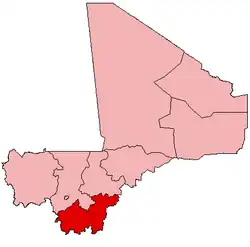
 Yognogo Location in Mali | |
| Coordinates: 12°27′31″N 5°18′53″W / 12.45861°N 5.31472°W | |
| Country | |
| Region | Sikasso Region |
| Cercle | Koutiala Cercle |
| Area | |
• Total | 66 km2 (25 sq mi) |
| Population (2009)[2] | |
• Total | 5,700 |
| • Density | 86/km2 (220/sq mi) |
| Time zone | UTC+0 (GMT) |
Yognogo is a commune in the Cercle of Koutiala in the Sikasso Region of southern Mali. The commune covers an area of 66 square kilometers and includes 3 villages (Bereniakan, Famessasso, and Koumbri).[3] In the 2009 census it had a population of 5,700.[2] The village of Famessasso, the administrative centre (chef-lieu) of the commune, is 20 km northeast of Koutiala near the Route Nationale 13 that links Koutiala with San.
References
- ^ Common and Fundamental Operational Datasets Registry: Mali, United Nations Office for the Coordination of Humanitarian Affairs, archived from the original on January 6, 2012. commune_mali.zip (Originally from the Direction Nationale des Collectivités Territoriales, République du Mali)
- ^ a b Resultats RGPH 2009 (Région de Sikasso) (PDF) (in French), République de Mali: Institut National de la Statistique, archived (PDF) from the original on 27 July 2012
{{citation}}: CS1 maint: publisher location (link). - ^ Communes de la Région de Sikasso (PDF) (in French), Ministère de l’administration territoriale et des collectivités locales, République du Mali, archived (PDF) from the original on 3 December 2013.
External links
- Plan de Sécurité Alimentaire Commune Rurale de Yognogo 2006-2008 (PDF) (in French), Commissariat à la Sécurité Alimentaire, République du Mali, USAID-Mali, 2006.