Yr Aran
| Yr Aran | |
|---|---|
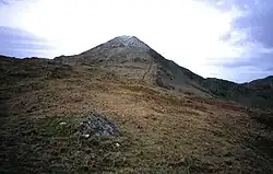
 Yr Aran from the Watkin path | |
| Highest point | |
| Elevation | 747.2 m (2,451 ft)[1] |
| Prominence | 235 m (771 ft) |
| Parent peak | Snowdon |
| Listing | Marilyn, Hewitt, Nuttall |
| Naming | |
| English translation | the peak |
| Language of name | Welsh |
| Pronunciation | Welsh: [ər ˈaran] |
| Geography | |
| Location | Gwynedd, Wales |
| Parent range | Snowdonia |
| OS grid | SH604515 |
| Topo map | OS Landranger 115 |
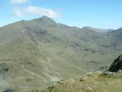
Yr Aran is a mountain peak on a ridge radiating south from Snowdon, Wales' highest mountain, with views of the summit of Snowdon, Moel Hebog and the Nantlle Ridge. It has an elevation of 747.2 m (2,451 ft) and a prominence of 235 m (771 ft).[1]
Although no paths are marked on maps, the ascent can be made as a detour from the Rhyd Ddu path or the Watkin Path up Snowdon.[2]
References
- ^ a b "Yr Aran". hill-bagging.co.uk. Database of British and Irish Hills. Retrieved 2 February 2024.
- ^ "Walk up Yr Aran from Rhyd Ddu | Walking In Eryri Snowdonia". Walk up Yr Wyddfa Snowdon. 13 November 2017. Retrieved 25 October 2024.
External links
53°02′33″N 4°05′01″W / 53.04249°N 4.08372°W