Isla Zacate Grande
| Isla Zacate Grande | |
|---|---|
 Zacate Grande | |
| Highest point | |
| Elevation | 640 m (2,100 ft) |
| Prominence | 640 m (2,100 ft) |
| Coordinates | 13°20′10″N 87°37′41″W / 13.336°N 87.628°W |
| Geography | |
| Location | Gulf of Fonseca, Honduras |
| Parent range | Central America Volcanic Arc |
| Geology | |
| Rock age | Holocene |
| Mountain type | Stratovolcano (extinct) |
| Volcanic arc | Central America Volcanic Arc |
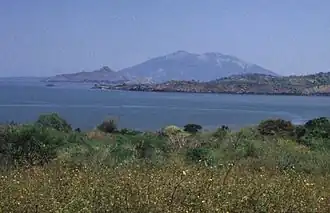
Isla Zacate Grande is a stratovolcano in Honduras. The volcano forms a 7 by 10 km (4 by 6 mi) island in the Gulf of Fonseca and has seven satellite cones, including Guegensi Island located 3 km (2 mi) from Zacate Grande.[1] The island has seven of the 13 Aldeas (known as towns or neighborhoods) son of the city Amapala. These are subdivided into hamlets.
References