Zafarobod District, Tajikistan
Zafarobod District
| |
|---|---|
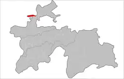 Location of Zafarobod District in Tajikistan | |
| Coordinates: 40°10′N 68°55′E / 40.167°N 68.917°E | |
| Country | |
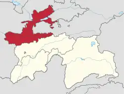
| Region | Sughd Region |
| Capital | Zafarobod |
| Area | |
• Total | 400 km2 (200 sq mi) |
| Population (2020)[1] | |
• Total | 75,900 |
| • Density | 190/km2 (490/sq mi) |
| Time zone | UTC+5 (TJT) |
Zafarobod District (Tajik: Ноҳияи Зафаробод, Nohiyai Zafarobod) is a district in Sughd Region, Tajikistan. Its capital is Zafarobod. The population of the district is 75,900 (January 2020 estimate).[1] The entire population of the Yaghnob Valley was forcibly resettled in the Zafarabad region in the 1970s by the Soviets.[2]
Administrative divisions
The district has an area of about 400 km2 (200 sq mi) and is divided administratively into three towns and two jamoats.[3] They are as follows:[4][5]
| Jamoat | Population (Jan. 2020)[5] |
|---|---|
| Homid Aliev (town) | 11,500 |
| Mehnatobod (town) | 13,208 |
| Zafarobod (town) | 27,148 |
| Jomi | 7,264 |
| Ravshan | 16,363 |
References
- ^ a b "Population of the Republic of Tajikistan as of 1 January 2020" (PDF) (in Russian). Statistics office of Tajikistan. Archived from the original (PDF) on 1 June 2021. Retrieved 12 October 2020.
- ^ "History of the Yaghnobi People". yaghnobi.wordpress.com. 2007-10-15.
- ^ "Regions of the Republic of Tajikistan 2017" (PDF) (in Russian). Statistics office of Tajikistan. pp. 15–21. Archived from the original (PDF) on 28 March 2022. Retrieved 12 October 2020.
- ^ Jamoat-level basic indicators, United Nations Development Programme in Tajikistan, accessed 2 October 2020
- ^ a b Population of Zafarobod district
Capital: Khujand | |||||||||||||||||||||||||
|  | ||||||||||||||||||||||||
|
| |||||||||||||||||||||||||
| |||||||||||||||||||||||||