Adma, West Virginia
Adma | |
|---|---|
 Adma Location within the state of West Virginia  Adma Adma (the United States) | |
| Coordinates: 39°4′33″N 80°2′16″W / 39.07583°N 80.03778°W | |
| Country | |
| State | |
| County | |
| Elevation | 1,444 ft (440 m) |
| Time zone | UTC-5 (Eastern (EST)) |
| • Summer (DST) | UTC-4 (EDT) |
| GNIS ID | 1696988[1] |
Adma was an unincorporated community in Barbour County, West Virginia, United States. Adma is located along the former Baltimore and Ohio Railroad and the Tygart Valley River.[1][2]
References
- ^ a b c U.S. Geological Survey Geographic Names Information System: Adma, West Virginia
- ^ Audra Quadrangle, West Virginia (Map). 1 : 24,000. 7.5 Minute Series (Topographic). United States Geological Survey. 2023. Retrieved April 2, 2025.
Municipalities and communities of Barbour County, West Virginia, United States | ||
|---|---|---|
| City | 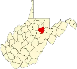 | |
| Magisterial districts |
| |
| Towns | ||
| CDPs | ||
| Unincorporated communities |
| |
| Ghost towns | ||