Brownton, West Virginia
Brownton, West Virginia | |
|---|---|
 Brownton, West Virginia  Brownton, West Virginia | |
| Coordinates: 39°13′12″N 80°09′00″W / 39.22000°N 80.15000°W | |
| Country | |
| State | |
| County | |
| Elevation | 338 m (1,109 ft) |
| Time zone | UTC-5 (Eastern (EST)) |
| • Summer (DST) | UTC-4 (EDT) |
| Area codes | 304 & 681 |
| GNIS feature ID | 1553996[1] |
Brownton is an unincorporated community and coal town in Barbour County, West Virginia, United States. Brownton is located along County Route 16, 3.35 miles (5.39 km) south-southwest of Flemington.[2] Brownton had a post office, which closed on January 24, 2004.[3]
References
- ^ a b U.S. Geological Survey Geographic Names Information System: Brownton, West Virginia
- ^ Barbour County, West Virginia General Highway Map (PDF) (Map). West Virginia Department of Transportation. 2011. p. 1. Retrieved March 5, 2012.
- ^ "Postmaster Finder - Post Offices by ZIP Code". United States Postal Service. Archived from the original on April 28, 2019. Retrieved March 5, 2012.
Municipalities and communities of Barbour County, West Virginia, United States | ||
|---|---|---|
| City | 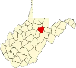 | |
| Magisterial districts |
| |
| Towns | ||
| CDPs | ||
| Unincorporated communities |
| |
| Ghost towns | ||