Alden, Oklahoma
Alden, Oklahoma | |
|---|---|
 Alden | |
| Coordinates: 34°58′31″N 98°35′07″W / 34.97528°N 98.58528°W | |
| Country | United States |
| State | Oklahoma |
| County | Caddo |
| Elevation | 1,480 ft (450 m) |
| Time zone | UTC-6 (Central (CST)) |
| • Summer (DST) | UTC-5 (CDT) |
| Area code | 405 |
| GNIS feature ID | 1100166[1] |
Alden is an unincorporated community in western Caddo County, Oklahoma, United States.[1] Alden is one mile east of Oklahoma State Highway 58 approximately 9 miles (14 km) south of Carnegie.[2] The town is old enough to appear on a 1911 Rand McNally map of the county.[3]
References
- ^ a b c U.S. Geological Survey Geographic Names Information System: Alden, Oklahoma
- ^ Oklahoma Atlas & Gazetteer, DeLorme, 1st ed., 1998, p.50 ISBN 0899332838
- ^ "Caddo County, Oklahoma 1911 Map". Rand McNally (accessed on MyGenealogyHound website). Retrieved March 7, 2025.
Municipalities and communities of Caddo County, Oklahoma, United States | ||
|---|---|---|
| City | 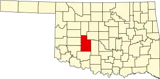 | |
| Towns | ||
| CDP | ||
| Other communities | ||
| Footnotes | ‡This populated place also has portions in an adjacent county or counties. | |