Stecker, Oklahoma
Stecker, Oklahoma | |
|---|---|
 Stecker | |
| Coordinates: 34°57′27″N 98°18′57″W / 34.95750°N 98.31583°W | |
| Country | United States |
| State | Oklahoma |
| County | Caddo |
| Elevation | 1,352 ft (412 m) |
| Time zone | UTC-6 (Central (CST)) |
| • Summer (DST) | UTC-5 (CDT) |
| Area code | 580 |
| GNIS feature ID | 1098511[1] |
Stecker is an unincorporated community in Caddo County, Oklahoma, United States, located 5 miles (8.0 km) northeast of Apache.[2] Stecker is old enough to appear on a 1911 Rand McNally map of the county, situated along the route of the old Rock Island railway.[3]
References
- ^ a b U.S. Geological Survey Geographic Names Information System: Stecker, Oklahoma
- ^ Shirk, George H. Oklahoma Place Names, Norman, Oklahoma: University of Oklahoma Press, 1965, p.198.
- ^ "Caddo County, Oklahoma 1911 Map". Rand McNally (accessed on MyGenealogyHound website). Retrieved March 7, 2025.
Municipalities and communities of Caddo County, Oklahoma, United States | ||
|---|---|---|
| City | 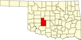 | |
| Towns | ||
| CDP | ||
| Other communities | ||
| Footnotes | ‡This populated place also has portions in an adjacent county or counties. | |