Alma, Alabama
Alma, Alabama | |
|---|---|
 Alma, Alabama Location within the state of Alabama  Alma, Alabama Alma, Alabama (the United States) | |
| Coordinates: 31°27′50.4″N 87°45′10.8″W / 31.464000°N 87.753000°W | |
| Country | United States |
| State | Alabama |
| County | Clarke |
| Elevation | 259 ft (79 m) |
| Time zone | UTC-6 (Central (CST)) |
| • Summer (DST) | UTC-5 (CDT) |
| ZIP code | 36501 |
| Area code | 251 |
Alma is an unincorporated community in Clarke County, Alabama, United States. The community was named for Alma Flinn, a local teacher.[1]
Geography
Alma is located at 31°27′50″N 87°45′11″W / 31.464°N 87.753°W and has an elevation of 259 feet (79 m).[1]
Demographics
According to the returns from 1850[2]-2010[3] for Alabama, it has never reported a population figure separately on the U.S. Census.[4]
References
- ^ a b "Alma, Alabama". ePodunk Community Profiles. Archived from the original on June 9, 2011. Retrieved January 16, 2008.
- ^ http://www2.census.gov/prod2/decennial/documents/1850c-11.pdf, 1850 Census (places)
- ^ http://www.census.gov/prod/cen2010/cph-1-2.pdf, 2010 AL Census
- ^ "US Census Bureau Publications - Census of Population and Housing".
Municipalities and communities of Clarke County, Alabama, United States | ||
|---|---|---|
| Cities | 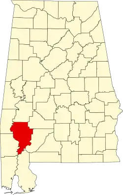 | |
| Towns | ||
| CDPs | ||
| Unincorporated communities | ||
| Ghost towns | ||