Arravonitsa
Arravonitsa
Αρραβωνίτσα | |
|---|---|
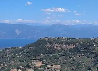 The plateau and the village of Arravonitsa as seen from Myrovrysi. | |
 Arravonitsa | |
| Coordinates: 38°15′N 21°58′E / 38.250°N 21.967°E | |
| Country | Greece |
| Administrative region | West Greece |
| Regional unit | Achaea |
| Municipality | Aigialeia |
| Municipal unit | Erineos |
| Village established | before 1692[1] |
| Elevation | 473 m (1,552 ft) |
| Population (2021)[2] | |
• Community | 136 |
| Time zone | UTC+2 (EET) |
| • Summer (DST) | UTC+3 (EEST) |
| Postal code | 251 00 |
| Area code(s) | 2691 |
| Vehicle registration | AX |
Arravonitsa (Greek: Αρραβωνίτσα) is a village and a community in the municipal unit of Erineos, Achaea, Greece. It is located in a hilly area, 15 km west of Aigio. The community consists of the villages Arravonitsa and Synania.
Population
| Year | Population |
|---|---|
| 1981 | 361 |
| 1991 | 362 |
| 2001 | 263 |
| 2011 | 189 |
| 2021 | 136 |
See also
References
- ^ "Αρραβωνίτσα Αχαΐας: Ιστορία/History".
- ^ "Αποτελέσματα Απογραφής Πληθυσμού - Κατοικιών 2021, Μόνιμος Πληθυσμός κατά οικισμό" [Results of the 2021 Population - Housing Census, Permanent population by settlement] (in Greek). Hellenic Statistical Authority. 29 March 2024.