Sympoliteia (municipality)
Sympoliteia
Συμπολιτεία | |
|---|---|
 Sympoliteia Location within the regional unit 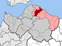 | |
| Coordinates: 38°16′N 22°03′E / 38.267°N 22.050°E | |
| Country | Greece |
| Administrative region | West Greece |
| Regional unit | Achaea |
| Municipality | Aigialeia |
| Area | |
| • Municipal unit | 85.505 km2 (33.014 sq mi) |
| Elevation | 174 m (571 ft) |
| Population (2021)[1] | |
| • Municipal unit | 6,162 |
| • Municipal unit density | 72/km2 (190/sq mi) |
| Time zone | UTC+2 (EET) |
| • Summer (DST) | UTC+3 (EEST) |
| Postal code | 251 00 |
| Area code(s) | 2691 |
| Vehicle registration | ΑΧ |
Sympoliteia (Greek: Συμπολιτεία) is a former municipality in Achaea, West Greece, Greece. Since the 2011 local government reform it is part of the municipality Aigialeia, of which it is a municipal unit.[2] The municipal unit has an area of 85.505 km2.[3] Population 6,162 (2021).[1] The seat of the municipality was in Rododafni.
References
- ^ a b "Αποτελέσματα Απογραφής Πληθυσμού - Κατοικιών 2021, Μόνιμος Πληθυσμός κατά οικισμό" [Results of the 2021 Population - Housing Census, Permanent population by settlement] (in Greek). Hellenic Statistical Authority. 29 March 2024.
- ^ "ΦΕΚ B 1292/2010, Kallikratis reform municipalities" (in Greek). Government Gazette.
- ^ "Population & housing census 2001 (incl. area and average elevation)" (PDF) (in Greek). National Statistical Service of Greece.
External links
- Municipality of Sympoliteia (in Greek)