Běhařov
Běhařov | |
|---|---|
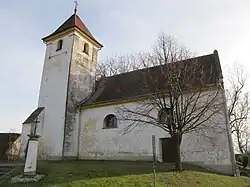 Church of Saint Procopius | |
 Flag 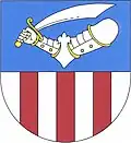 Coat of arms | |
 Běhařov Location in the Czech Republic | |
| Coordinates: 49°20′42″N 13°9′37″E / 49.34500°N 13.16028°E | |
| Country | |
| Region | Plzeň |
| District | Klatovy |
| First mentioned | 1352 |
| Area | |
• Total | 4.37 km2 (1.69 sq mi) |
| Elevation | 485 m (1,591 ft) |
| Population (2025-01-01)[1] | |
• Total | 185 |
| • Density | 42/km2 (110/sq mi) |
| Time zone | UTC+1 (CET) |
| • Summer (DST) | UTC+2 (CEST) |
| Postal code | 340 21 |
| Website | www |
Běhařov (German: Wihorschau) is a municipality and village in Klatovy District in the Plzeň Region of the Czech Republic. It has about 200 inhabitants.
Běhařov lies approximately 11 kilometres (7 mi) south-west of Klatovy, 48 km (30 mi) south of Plzeň, and 123 km (76 mi) south-west of Prague.
Administrative division
Běhařov consists of two municipal parts (in brackets population according to the 2021 census):[2]
- Běhařov (116)
- Úborsko (50)
Demographics
| Year | Pop. | ±% |
|---|---|---|
| 1869 | 514 | — |
| 1880 | 533 | +3.7% |
| 1890 | 468 | −12.2% |
| 1900 | 475 | +1.5% |
| 1910 | 459 | −3.4% |
| 1921 | 479 | +4.4% |
| 1930 | 417 | −12.9% |
| 1950 | 306 | −26.6% |
| 1961 | 262 | −14.4% |
| 1970 | 217 | −17.2% |
| 1980 | 179 | −17.5% |
| 1991 | 149 | −16.8% |
| 2001 | 152 | +2.0% |
| 2011 | 221 | +45.4% |
| 2021 | 166 | −24.9% |
| Source: Censuses[3][4] | ||
References
- ^ "Population of Municipalities – 1 January 2025". Czech Statistical Office. 2025-05-16.
- ^ "Public Census 2021 – basic data". Public Database (in Czech). Czech Statistical Office. 2022.
- ^ "Historický lexikon obcí České republiky 1869–2011" (in Czech). Czech Statistical Office. 2015-12-21.
- ^ "Population Census 2021: Population by sex". Public Database. Czech Statistical Office. 2021-03-27.
External links
Wikimedia Commons has media related to Běhařov.