Spodnja Bačkova
Spodnja Bačkova | |
|---|---|
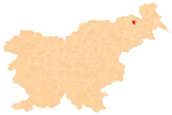
 Spodnja Bačkova Location in Slovenia | |
| Coordinates: 46°38′14.83″N 15°52′56.38″E / 46.6374528°N 15.8823278°E | |
| Country | |
| Traditional region | Styria |
| Statistical region | Drava |
| Municipality | Benedikt |
| Area | |
• Total | 2.45 km2 (0.95 sq mi) |
| Elevation | 304.5 m (999.0 ft) |
| Population (2020) | |
• Total | 132 |
| • Density | 54/km2 (140/sq mi) |
| [1] | |
Spodnja Bačkova (pronounced [ˈspoːdnja ˈbaːtʃkɔʋa]) is a settlement in the Slovene Hills (Slovene: Slovenske gorice) in the Municipality of Benedikt in northeastern Slovenia. The area is part of the traditional region of Styria. It is now included in the Drava Statistical Region.[2]
History
Spodnja Bačkova was created as a separate settlement in 1963, when the former village of Bačkova was split into this settlement and neighboring Zgornja Bačkova.[3]
Cultural heritage
A small hexagonal chapel-shrine in the settlement dates to 1871.[4]
References
- ^ Statistical Office of the Republic of Slovenia
- ^ Benedikt municipal site
- ^ Marinković, Dragan (1991). Abecedni spisak naselja u SFRJ. Promene u sastavu i nazivima naselja za period 1948–1990. Belgrade: Savezni zavod za statistiku. pp. 2, 95, 120.
- ^ Slovenian Ministry of Culture register of national heritage reference number ešd 3818
External links
| Settlements | Administrative seat: Benedikt
|  | ||||
|---|---|---|---|---|---|---|