Babra taluka
Babra taluka | |
|---|---|
| Coordinates: 21°50′39″N 71°18′15″E / 21.8441667°N 71.3041667°E | |
| Country | |
| State | Gujarat |
| District | Amreli |
| Headquarters | Babra |
| Population (2011)[1] | |
• Total | 140,521 |
| • Sex ratio | 954 ♂/♀ |
| • Literacy | 62.5% |
| Languages | |
| • Official | Gujarati, Hindi |
| Time zone | UTC+5:30 (IST) |
| Telephone code | +91-079 |
| Vehicle registration | GJ |
| Website | amreli |
Babra Taluka is a sub-divisional administrative region situated within the Amreli district of the state of Gujarat, India.[2]
Geography
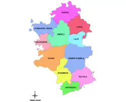
Babra Taluka is a geographical sub-division located in the southern part of Saurashtra region in the western Indian state of Gujarat.[3]
References
- ^ "District wise Statistics | NITI Aayog, (National Institution for Transforming India), Government of India". 164.100.94.191. Retrieved 5 January 2023.
- ^ "Taluka | District Amreli, Government of Gujarat | India". Retrieved 29 August 2023.
- ^ "Villages & Towns in Babra Taluka of Amreli, Gujarat". www.census2011.co.in. Retrieved 29 August 2023.
External links
- Official website

 Geographic data related to Babra taluka at OpenStreetMap
HQ: Amreli | |||||||
| history | .svg.png) | ||||||
| geography |
| ||||||
| Taluks (headquarters) | |||||||