Banner, Missouri
Banner, Missouri | |
|---|---|
 Banner  Banner | |
| Coordinates: 37°41′49″N 90°50′04″W / 37.69694°N 90.83444°W | |
| Country | United States |
| State | Missouri |
| County | Iron |
| Elevation | 1,034 ft (315 m) |
| Time zone | UTC-6 (Central (CST)) |
| • Summer (DST) | UTC-5 (CDT) |
| Area code | 573 |
| GNIS feature ID | 784661[1] |
Banner is an unincorporated community in northern Iron County, in the U.S. state of Missouri.[1]
The community is located on the banks of Keesling Branch one half mile from that stream's confluence with Cedar Creek[2] on Missouri Route 32 approximately 5 miles (8.0 km) west of Belleview.[3]
History
A post office called Banner was established in 1924 in Kaolin Township[4] and remained in operation until 1956.[5] It is unknown why the name "Banner" was applied to this community.[6] A variant name was "Brule".[1]
References
- ^ a b c d U.S. Geological Survey Geographic Names Information System: Banner
- ^ Banner, MO, 7.5 Minute Topographic Quadrangle, USGS, 1968
- ^ Missouri Atlas & Gazetteer, DeLorme, 1998, First edition, p. 48 ISBN 0-89933-224-2
- ^ "Iron County | The State Historical Society of Missouri". collections.shsmo.org. Retrieved May 5, 2025.
- ^ "Post Offices". Jim Forte Postal History. Archived from the original on October 12, 2016. Retrieved October 11, 2016.
- ^ "Iron County Place Names, 1928–1945 (archived)". The State Historical Society of Missouri. Archived from the original on June 24, 2016. Retrieved October 11, 2016.
Municipalities and communities of Iron County, Missouri, United States | ||
|---|---|---|
| Cities | 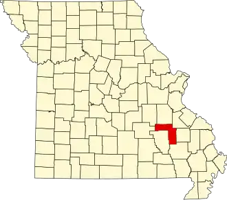 | |
| Village | ||
| Townships | ||
| Unincorporated communities | ||
| Ghost towns | ||
| Footnotes | ‡This populated place also has portions in an adjacent county or counties | |