Ghermanville, Missouri
Ghermanville, Missouri | |
|---|---|
 Ghermanville  Ghermanville | |
| Coordinates: 37°38′56″N 90°40′12″W / 37.64889°N 90.67000°W | |
| Country | United States |
| State | Missouri |
| County | Iron |
| Elevation | 1,191 ft (363 m) |
| Time zone | UTC-6 (Central (CST)) |
| • Summer (DST) | UTC-5 (CDT) |
| Area code | 573 |
| GNIS feature ID | 736626[1] |
Ghermanville is an unincorporated community in northeastern Iron County, in the U.S. state of Missouri.[1] The community was located approximately one-half mile east of Graniteville adjacent to Missouri Route 21.[2]
History
A post office called Ghermanville was established in 1889, and remained in operation until 1894.[3] The community was named after a local merchant.[4]
References
- ^ a b c U.S. Geological Survey Geographic Names Information System: Ghermanville, Missouri
- ^ Per coordinates on Ironton, Mo, 15 Minute Topographic Quadrangle, USGS, 1937
- ^ "Post Offices". Jim Forte Postal History. Archived from the original on October 12, 2016. Retrieved October 11, 2016.
- ^ "Iron County Place Names, 1928–1945 (archived)". The State Historical Society of Missouri. Archived from the original on June 24, 2016. Retrieved October 11, 2016.
{{cite web}}: CS1 maint: bot: original URL status unknown (link)
Municipalities and communities of Iron County, Missouri, United States | ||
|---|---|---|
| Cities | 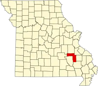 | |
| Village | ||
| Townships | ||
| Unincorporated communities | ||
| Ghost towns | ||
| Footnotes | ‡This populated place also has portions in an adjacent county or counties | |