Birdbrook railway station
Birdbrook | |||||
|---|---|---|---|---|---|
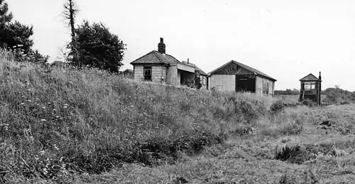 View in 1962 | |||||
| General information | |||||
| Location | Birdbrook, Braintree England | ||||
| Coordinates | 52°02′59″N 0°30′03″E / 52.0498°N 0.5007°E | ||||
| Platforms | 1 | ||||
| Other information | |||||
| Status | Disused | ||||
| History | |||||
| Original company | Colne Valley and Halstead Railway | ||||
| Pre-grouping | Colne Valley and Halstead Railway | ||||
| Post-grouping | London and North Eastern Railway | ||||
| Key dates | |||||
| 10 May 1863 | Opened[1] | ||||
| 1 Jan 1962 | Closed | ||||
| |||||
Birdbrook railway station was located 0.7 miles (1.1 km) to the northeast of the village of Birdbrook, Essex. It was 65 miles 74 chains (106.10 km; 65.93 mi) from London Liverpool Street via Marks Tey.[2] It opened in 1863 as the replacement for Whitley station, and closed in 1962.[3]
Former Services
| Preceding station | Disused railways | Following station | ||
|---|---|---|---|---|
| Haverhill South Line and station closed |
Colne Valley and Halstead Railway to 1924 |
Whitley Line and station closed | ||
| Haverhill North Line and station closed |
London and North Eastern Railway Colne Valley and Halstead line 1924 on |
Whitley Line and station closed |
References
- ^ Butt, R. V. J. (October 1995). The Directory of Railway Stations: details every public and private passenger station, halt, platform and stopping place, past and present (1st ed.). Sparkford: Patrick Stephens Ltd. ISBN 978-1-85260-508-7. OCLC 60251199. OL 11956311M.
- ^ "ELR: COV mileages".
- ^ "Disused Stations: Birdbrook Station". www.subbrit.org.uk. Retrieved 17 October 2018.
External links
- Birdbrook station on navigable 1946 O. S. map
- "Disused Stations". Subterranea Britannica.
- Birdbrook station on Birdbrook Village Website