Bradfield railway station
Bradfield | |||||
|---|---|---|---|---|---|
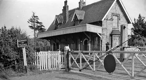 Bradfield station in June 1963 | |||||
| General information | |||||
| Location | Bradfield, Tendring England | ||||
| Platforms | 2 | ||||
| Other information | |||||
| Status | Disused | ||||
| History | |||||
| Original company | Eastern Union Railway[1] Eastern Counties Railway | ||||
| Pre-grouping | Great Eastern Railway | ||||
| Post-grouping | London and North Eastern Railway | ||||
| Key dates | |||||
| 15 August 1854 | Opened[1] | ||||
| 2 July 1956 | Closed | ||||
| |||||
Bradfield railway station served the village of Bradfield in Essex. It was on the Manningtree to Harwich branch line, which is today known as The Mayflower Line.[2] It closed in 1956. Consisting of just two through platforms it had no sidings for working local goods traffic, which was the normal scenario in rural East Anglia.[3] The station buildings on the up platform were particularly splendid for a very small station and were captured by the well known and popular transport artist Malcolm Root FGRA.[4] The facilities on the down platform were very modest by comparison. The station had a very restricted catchment area and with a local population of just 730 in 1901 and 811 in 1961, passenger numbers were always very limited.[5] A level crossing at the west end of the station was controlled by a signal box on the up side with just 12 levers.[6]
| Preceding station | Historical railways | Following station | ||
|---|---|---|---|---|
| Mistley Line and station open |
Eastern Region of British Railways Mayflower line |
Priory Halt Line open, station closed | ||
References
- ^ a b Butt, R. V. J. (October 1995). The Directory of Railway Stations: details every public and private passenger station, halt, platform and stopping place, past and present (1st ed.). Sparkford: Patrick Stephens Ltd. p. 41. ISBN 978-1-85260-508-7. OCLC 60251199. OL 11956311M.
- ^ Body, Geoffrey (1986). PSL Field Guide, Railways of the Eastern Region, Vol. 1. Wellingborough: Patrick Stephens Ltd. p. 81. ISBN 0-85059-712-9.
- ^ Mitchell, Vic (June 2011). Branch Lines to Harwich and Hadleigh. Midhurst: Middleton Press. Plan IV and Plate 29. ISBN 978-1-908174-02-4.
- ^ Mitchell 2011, rear cover
- ^ Mitchell 2011, plate 29
- ^ Mitchell 2011, plate 30
External links
51°56′24″N 1°06′40″E / 51.93995°N 1.11112°E