Birgland
Birgland | |
|---|---|
 Birgland | |
 Flag  Coat of arms | |
Location of Birgland within Amberg-Sulzbach district 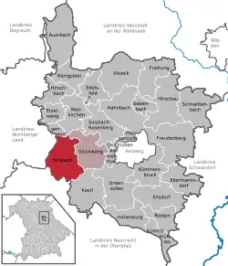 | |
 Birgland  Birgland | |
| Coordinates: 49°25′N 11°38′E / 49.417°N 11.633°E | |
| Country | Germany |
| State | Bavaria |
| Admin. region | Oberpfalz |
| District | Amberg-Sulzbach |
| Municipal assoc. | Illschwang |
| Government | |
| • Mayor (2020–26) | Brigitte Bachmann[1] (SPD) |
| Area | |
• Total | 62.40 km2 (24.09 sq mi) |
| Elevation | 390 m (1,280 ft) |
| Population (2024-12-31)[2] | |
• Total | 1,828 |
| • Density | 29/km2 (76/sq mi) |
| Time zone | UTC+01:00 (CET) |
| • Summer (DST) | UTC+02:00 (CEST) |
| Postal codes | 92262 |
| Dialling codes | 09666 |
| Vehicle registration | AS |
| Website | www.birgland.de |
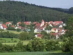
Birgland is a municipality in the district of Amberg-Sulzbach in Bavaria in Germany.
Geography
There is no village called Birgland, the municipality Birgland consists of the following villages:[3]
- Aicha
- Ammerried
- Ammersricht
- Baumgarten
- Betzenberg
- Buchhof
- Burkartshof
- Dickatshof
- Dollmannsberg
- Eckeltshof
- Eckertsfeld
- Frechetsfeld
- Fürnried
- Geigenwang
- Gronatshof
- Hainfeld
- Haslach
- Hirschricht
- Höfling
- Kegelheim
- Kutschendorf
- Leinberg
- Leinhof
- Lichtenegg
- Matzenhof
- Nonnhof
- Ödamershüll
- Ödhaag
- Ödthal
- Pleishof
- Poppberg
- Reichenunholden
- Riedelhof
- Rothsricht
- Schwend
- Schwenderöd
- Sunzendorf
- Tannlohe
- Troßalter
- Wolfertsfeld
- Woppenthal
- Wurmrausch
Notable people
References
- ^ Liste der ersten Bürgermeister/Oberbürgermeister in kreisangehörigen Gemeinden, Bayerisches Landesamt für Statistik, 15 July 2021.
- ^ "Gemeinden, Kreise und Regierungsbezirke in Bayern, Einwohnerzahlen am 31. Dezember 2024; Basis Zensus 2022" [Municipalities, counties, and administrative districts in Bavaria; Based on the 2022 Census] (CSV) (in German). Bayerisches Landesamt für Statistik.
- ^ "Ortsteile mit Postleitzahl". Retrieved 2024-02-15.
Wikimedia Commons has media related to Birgland.
Towns and municipalities in Amberg-Sulzbach | ||
|---|---|---|
|  | |