Ensdorf, Bavaria
Ensdorf | |
|---|---|
 Church of Saint James the Greater | |
 Flag 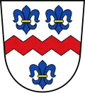 Coat of arms | |
Location of Ensdorf within Amberg-Sulzbach district 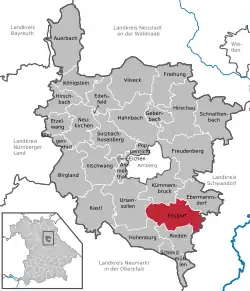 | |
 Ensdorf  Ensdorf | |
| Coordinates: 49°21′N 11°56′E / 49.350°N 11.933°E | |
| Country | Germany |
| State | Bavaria |
| Admin. region | Oberpfalz |
| District | Amberg-Sulzbach |
| Government | |
| • Mayor (2020–26) | Hans Ram[1] (SPD) |
| Area | |
• Total | 41.45 km2 (16.00 sq mi) |
| Elevation | 469 m (1,539 ft) |
| Population (2024-12-31)[2] | |
• Total | 2,160 |
| • Density | 52/km2 (130/sq mi) |
| Time zone | UTC+01:00 (CET) |
| • Summer (DST) | UTC+02:00 (CEST) |
| Postal codes | 92266 |
| Dialling codes | 09624 |
| Vehicle registration | AS |
| Website | www.ensdorf.de |
Ensdorf (German pronunciation: [ˈɛnsˌdɔʁf]) is a municipality in the district of Amberg-Sulzbach in Bavaria in Germany.
Geography
Apart from Ensdorf the municipality consists of the following villages:[3]
- Dornberg
- Götzenöd
- Hirschwald
- Hofstetten
- Langenwies
- Leidersdorf
- Oberbernstein
- Palkering
- Rannahof
- Ruiding
- Schwabenhof
- Seidlthal
- Seulohe
- Thanheim
- Unterbernstein
- Uschlberg
- Wolfsbach
Population development
Inhabitants:
- 1933: 825
- 1939: 761
- 1961: 1765
- 1970: 1902
- 1987: 1934
- 1995: 2142
- 2000: 2222
- 2010: 2227
- 2015: 2219
Mayor
Since May 2020 Hans Ram (SPD) is the mayor.[1]
Notable people
References
- ^ a b Liste der ersten Bürgermeister/Oberbürgermeister in kreisangehörigen Gemeinden, Bayerisches Landesamt für Statistik, 15 July 2021.
- ^ "Gemeinden, Kreise und Regierungsbezirke in Bayern, Einwohnerzahlen am 31. Dezember 2024; Basis Zensus 2022" [Municipalities, counties, and administrative districts in Bavaria; Based on the 2022 Census] (CSV) (in German). Bayerisches Landesamt für Statistik.
- ^ "Ortsteile mit Postleitzahl". Retrieved 2024-02-15.
Wikimedia Commons has media related to Ensdorf (Oberpfalz).
Towns and municipalities in Amberg-Sulzbach | ||
|---|---|---|
|  | |