Bolle Bay
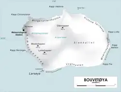
Bolle Bay (54°27′S 3°21′E / 54.450°S 3.350°E) is a cove indenting the western shore of Bouvetøya, entered on the southern side of Norvegia Point. Roughly charted in 1898 by the German expedition under Carl Chun, it was re-charted and named in December 1927 by a Norwegian expedition under Captain Harald Horntvedt.[1][2]
References
- ^ "Prof. Dr. phil., Dr. med. h. c. Carl Chun". University of Leipzig. Retrieved October 1, 2016.
- ^ "Norvegia-ekspedisjonene". Store norske leksikon. Retrieved October 1, 2016.
Other sources
- Simpson-Housley, Paul (2002) Antarctica: Exploration, Perception and Metaphor (Routledge) ISBN 9781134891214
 This article incorporates public domain material from "Bolle Bay". Geographic Names Information System. United States Geological Survey.