Bransford, Tennessee
Bransford, Tennessee | |
|---|---|
 Bransford, Tennessee | |
| Coordinates: 36°30′15″N 86°16′12″W / 36.50417°N 86.27000°W | |
| Country | United States |
| State | Tennessee |
| County | Sumner |
| Area | |
• Total | 4.03 sq mi (10.44 km2) |
| • Land | 4.03 sq mi (10.44 km2) |
| • Water | 0.00 sq mi (0.00 km2) |
| Elevation | 571 ft (174 m) |
| Population | |
• Total | 166 |
| • Density | 41.20/sq mi (15.91/km2) |
| Time zone | UTC-6 (Central (CST)) |
| • Summer (DST) | UTC-5 (CDT) |
| ZIP code | 37022[3] |
| Area code | 615 |
| GNIS feature ID | 1314725[4] |
Bransford is a census-designated place and unincorporated community in Sumner County, Tennessee, United States. Its population was 170 as of the 2010 census.[5]
Demographics
| Census | Pop. | Note | %± |
|---|---|---|---|
| 2020 | 166 | — | |
| U.S. Decennial Census[6] | |||
References
- ^ "ArcGIS REST Services Directory". United States Census Bureau. Retrieved October 15, 2022.
- ^ "Census Population API". United States Census Bureau. Retrieved October 15, 2022.
- ^ "Bransford TN ZIP Code". zipdatamaps.com. 2023. Retrieved February 17, 2023.
- ^ "Bransford". Geographic Names Information System. United States Geological Survey, United States Department of the Interior.
- ^ "U.S. Census website". United States Census Bureau. Retrieved May 14, 2011.
- ^ "Census of Population and Housing". Census.gov. Retrieved June 4, 2016.
Municipalities and communities of Sumner County, Tennessee, United States | ||
|---|---|---|
| Cities | 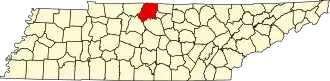 | |
| Town | ||
| CDPs | ||
| Unincorporated communities | ||
| Footnotes | ‡This populated place also has portions in an adjacent county or counties | |