Graball, Sumner County, Tennessee
Graball, Tennessee | |
|---|---|
 Graball Market in Graball | |
 Graball, Tennessee | |
| Coordinates: 36°28′57″N 86°26′17″W / 36.48250°N 86.43806°W | |
| Country | United States |
| State | Tennessee |
| County | Sumner |
| Area | |
• Total | 2.006 sq mi (5.20 km2) |
| • Land | 2.006 sq mi (5.20 km2) |
| • Water | 0 sq mi (0 km2) |
| Elevation | 932 ft (284 m) |
| Population (2020) | |
• Total | 228 |
| • Density | 110/sq mi (44/km2) |
| Time zone | UTC-6 (Central (CST)) |
| • Summer (DST) | UTC-5 (CDT) |
| Area code | 615 |
| GNIS feature ID | 1285768[2] |
Graball is a census-designated place and unincorporated community in Sumner County, Tennessee, United States. As of the 2020 census, its population was 228,[3] slightly down from 236 at the 2010 census.[4]
References
- ^ "US Gazetteer files: 2010, 2000, and 1990". United States Census Bureau. February 12, 2011. Retrieved April 23, 2011.
- ^ "Graball". Geographic Names Information System. United States Geological Survey, United States Department of the Interior.
- ^ "Explore Census Data". United States Census Bureau. Retrieved May 4, 2024.
- ^ "Census.gov". United States Census Bureau. Retrieved May 4, 2024.
Municipalities and communities of Sumner County, Tennessee, United States | ||
|---|---|---|
| Cities | 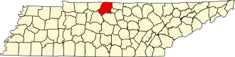 | |
| Town | ||
| CDPs | ||
| Unincorporated communities | ||
| Footnotes | ‡This populated place also has portions in an adjacent county or counties | |