Burning Fork, Kentucky
Burning Fork, Kentucky | |
|---|---|
 Burning Fork  Burning Fork | |
| Coordinates: 37°44′0″N 83°1′24″W / 37.73333°N 83.02333°W | |
| Country | United States |
| State | Kentucky |
| County | Magoffin |
| Elevation | 899 ft (274 m) |
| Time zone | UTC-5 (Eastern (EST)) |
| • Summer (DST) | UTC-4 (EDT) |
| ZIP codes | 41405 |
| GNIS feature ID | 507625[1] |
Burning Fork is an unincorporated community located in Magoffin County, Kentucky, United States. The etymology of Burning Fork refers to a natural gas vein that was ignited and eventually extinguished by 1865.[2][3]
References
- ^ U.S. Geological Survey Geographic Names Information System: Burning Fork, Kentucky
- ^ Rennick, Robert M. (2013). Kentucky Place Names. University Press of Kentucky. ISBN 9780813144016.
- ^ Collins, Lewis (1877). History of Kentucky. p. 536.
Municipalities and communities of Magoffin County, Kentucky, United States | ||
|---|---|---|
| City | 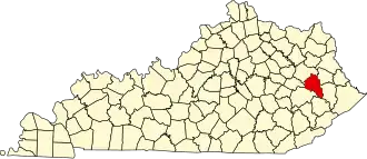 | |
| Unincorporated communities | ||