Foraker, Kentucky
Foraker, Kentucky | |
|---|---|
 Foraker  Foraker | |
| Coordinates: 37°39′36″N 83°8′14″W / 37.66000°N 83.13722°W | |
| Country | United States |
| State | Kentucky |
| County | Magoffin |
| Elevation | 892 ft (272 m) |
| Time zone | UTC-5 (Eastern (EST)) |
| • Summer (DST) | UTC-4 (EDT) |
| GNIS feature ID | 508021 |
Foraker is an unincorporated community in Magoffin County, Kentucky, United States. It lies along Kentucky Route 30 south of the city of Salyersville, the county seat of Magoffin County.[1] Its elevation is 892 feet (272 m).[2]
References
- ^ Rand McNally. The Road Atlas '06. Chicago: Rand McNally, 2006, p. 43.
- ^ U.S. Geological Survey Geographic Names Information System: Foraker, Kentucky
Municipalities and communities of Magoffin County, Kentucky, United States | ||
|---|---|---|
| City | 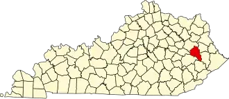 | |
| Unincorporated communities | ||