Campaigh
| Scottish Gaelic name | Campaigh |
|---|---|
| Old Norse name | Kambrey |
| Location | |
 Campaigh Campaigh shown within the Outer Hebrides | |
| OS grid reference | NB142426 |
| Coordinates | 58°18′N 6°52′W / 58.3°N 6.87°W |
| Physical geography | |
| Island group | Outer Hebrides |
| Area | <10 ha |
| Highest elevation | over 20 metres (66 ft) |
| Administration | |
| Council area | Comhairle nan Eilean Siar |
| Country | Scotland |
| Sovereign state | United Kingdom |
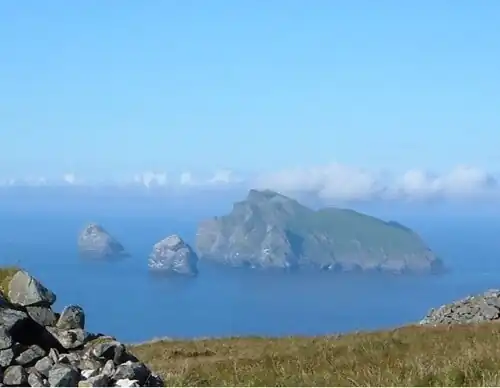
Campaigh or Campay is a steep and rocky islet in outer Loch Ròg, Lewis, Scotland that lies north of Cealasaigh and Little Bernera.
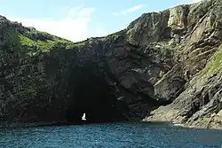
A huge natural arch transverses the northern half of the island from south west to north east and there is a large sea cave to the south.[1] The islet of Cùl Champaigh lies offshore to the north, and tiny Sgeir Dearg (red skerry) and the larger Màs Sgeir (seagull skerry) beyond.[2]
Notes
- ^ Haswell-Smith, Hamish (2004). The Scottish Islands. Edinburgh: Canongate. p. 312. ISBN 978-1-84195-454-7.
- ^ "Get-a-map" Archived 29 June 2011 at the Wayback Machine. Ordnance Survey. Retrieved 24 July 2010.
Wikimedia Commons has media related to Campaigh.
| Inhabited islands | ||
|---|---|---|
| Other islands | ||
| Settlements |
| |
| Districts | ||
| Geographical features | ||
| Historical sites | ||
|  | ||||||||||||||||
|
| |||||||||||||||||
| |||||||||||||||||
| |||||||||||||||||
| |||||||||||||||||
| |||||||||||||||||
| |||||||||||||||||
| |||||||||||||||||
58°16′44″N 6°52′35″W / 58.2789°N 6.8765°W