Castra of Sărățeni
| Castra of Sărățeni | |
|---|---|
 Location within Romania | |
| Abandoned | 4th or 5th century AD |
| Place in the Roman world | |
| Province | Dacia |
| Administrative unit | Dacia Porolissensis |
| Administrative unit | Dacia Superior |
| Limes | Porolissensis |
| Structure | |
| — Stone[1] structure — | |
| Size and area | 112 m × 148 m (1.6 [1] ha) |
| Stationed military units | |
| — Cohorts — | |
| I Alpinorum equitata[1][2] I Ubiorum[2] | |
| Location | |
| Coordinates | 46°33′46″N 25°00′53″E / 46.56270°N 25.01481°E |
| Place name | Castru |
| Town | Sărățeni |
| County | Mureș |
| Country | |
| Reference | |
| RO-LMI | MS-I-m-B-15416.01[3] |
| RO-RAN | 114907.01[3] |
| UNESCO | |
| Part of | Frontiers of the Roman Empire – Dacia |
| Criteria | Cultural: ii, iii, iv |
| Reference | 1718-219 |
| Inscription | 2024 (46th Session) |
| Site notes | |
| Recognition | |
| Condition | Ruined |
It was a fort in the Roman province of Dacia, at modern Sărățeni, Mureș County, Romania.
See also
External links
- Roman castra from Romania - Google Maps / Earth Archived 2012-01-17 at the Wayback Machine
Notes
- ^ a b c "Sărățeni". Archived from the original on 2012-10-16. Retrieved 2012-12-07.
- ^ a b Ureche, Petru (2009), Tactică, strategie și specific de luptă la cohortele equitate din Dacia Romană [Tactics, strategies and fighting specific of the cohortes equitatae in Roman Dacia] (PDF) (in Romanian), Bucharest: Near and Beyond the Roman Frontier. Proceedings of a colloquim held in Târgoviște, 16–17 October 2008, pp. 329–338
- ^ a b "National Archaeological Record (RAN)". ran.cimec.ro. Archived from the original on 19 September 2012. Retrieved 7 December 2012.
-
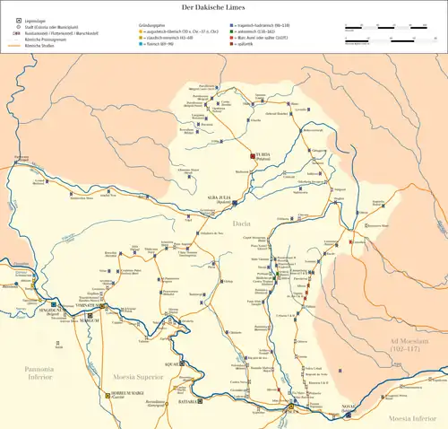 Map of the Limes in Dacia. The Castra of Sărățeni is located in the upper right corner.