Chapultepec, State of Mexico
Chapultepec | |
|---|---|
Municipality and town | |
 Seal | |
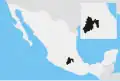
 Chapultepec Location in Mexico | |
| Coordinates: 19°13′N 98°51′W / 19.217°N 98.850°W | |
| Country | |
| State | |
| Government | |
| • Mayor | Paulina Alejandra Del Moral |
| Area | |
• Total | 10.45 km2 (4.03 sq mi) |
| Population (2020) | |
• Total | 12,772 |
| Time zone | UTC-6 (Central Standard Time) |
Chapultepec is a small town and municipality in the State of Mexico in Mexico. The municipality covers an area of 10.45 km².
Etymology
The name Chapultepec comes from Náhuatl meaning hill of the Grasshoppers.
Geography
The municipality of Chapultepec, which has a geographical extent of 9.676 km2 (6012.388 sq mi). The municipality is bordered by the municipalities of Toluca, Metepec, Mexicaltzingo, Calimaya and Tianguistenco.
In 2010, the municipality had a total population of 12,120.[1]
References
- ^ "Chapultepec". Enciclopedia de los Municipios de México. Instituto Nacional para el Federalismo y el Desarrollo Municipal. Archived from the original on May 26, 2007. Retrieved June 5, 2009.