Desteldonk
Desteldonk | |
|---|---|
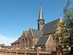 Church of Our Lady from the 14th century | |
Location of Desteldonk | |
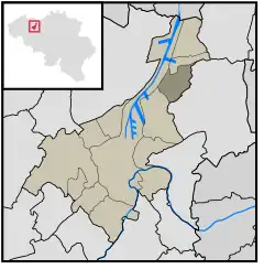 Location of Desteldonk in Ghent | |
 Desteldonk 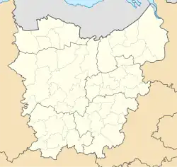 Desteldonk | |
| Coordinates: 51°7′19″N 3°46′52″E / 51.12194°N 3.78111°E | |
| Country | |
| Community | |
| Region | |
| Province | |
| Arrondissement | Ghent |
| Municipality | Ghent |
| Area | |
• Total | 5.71 km2 (2.20 sq mi) |
| Population (2021)[1] | |
• Total | 921 |
| • Density | 160/km2 (420/sq mi) |
| Postal codes | 9042 |
| Area codes | 09 |
Desteldonk (French pronunciation: [ˈdɛstəldɔŋk]) is a sub-municipality of the city of Ghent located in the province of East Flanders, Flemish Region, Belgium. It was a separate municipality until 1965. In 1927, part of the original municipality was already annexed to Ghent.[2] On 1 January 1965, the municipality of Desteldonk was merged into Ghent.[3]
The first historical record of Desteldonk dates back to 966 when it was listed as Thesledung. In 1236, it was named as a parish.
References
- ^ a b "Bevolking per statistische sector - Sector 44021D5". Statistics Belgium. Retrieved 8 May 2022.
- ^ "Desteldonk". Agentschap Onroerend Erfgoed (in Dutch). Retrieved 8 May 2022.
- ^ "LISTE ALPHABETIQUE DES COMMUNES - Fusions de 1963 à 1977" (PDF).
Wikimedia Commons has media related to Desteldonk.
Populated places in Ghent | ||
|---|---|---|
| Sub-municipalities | ||
| Neighbourhoods, villages and hamlets | ||