Devonport Airport
Devonport Airport | |||||||||||||||
|---|---|---|---|---|---|---|---|---|---|---|---|---|---|---|---|
 | |||||||||||||||
| Summary | |||||||||||||||
| Airport type | Public | ||||||||||||||
| Operator | TasPorts | ||||||||||||||
| Serves | Devonport, Tasmania, Australia | ||||||||||||||
| Elevation AMSL | 33 ft / 10 m | ||||||||||||||
| Coordinates | 41°10′11″S 146°25′49″E / 41.16972°S 146.43028°E | ||||||||||||||
| Website | Devonport Airport | ||||||||||||||
| Maps | |||||||||||||||
 YDPO Location in Tasmania | |||||||||||||||
| Runways | |||||||||||||||
| |||||||||||||||
| Statistics (2010/11[1]) | |||||||||||||||
| |||||||||||||||
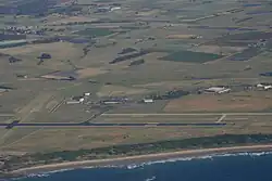
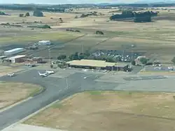
Devonport Airport (IATA: DPO[4], ICAO: YDPO) is a regional airport serving Devonport, a city in the Australian state of Tasmania.[2] It is located 10 km (6.2 mi) from the town centre at Pardoe Downs, on Wesley Vale and Airport Roads.[5] The airport is operated by TasPorts[2][6] which previously operated the larger Hobart Airport.
History
In late 1990, the airport was being served by East-West Airlines.[7]
Facilities
The airport is at an elevation of 33 ft (10 m) above sea level. It has two runways: 06/24 with an asphalt surface measuring 1,838 m × 45 m (6,030 ft × 148 ft) and 14/32 with a grass surface measuring 880 m × 30 m (2,887 ft × 98 ft).[2]
Airlines and destinations
| Airlines | Destinations |
|---|---|
| QantasLink | Melbourne–Tullamarine |
| Rex Airlines | Melbourne–Tullamarine |
| Southern Airlines | King Island, Melbourne–Moorabbin |
Statistics
Devonport Airport was ranked 40th in Australia for the number of revenue passengers served in financial year 2010–2011.[1][3]
| Year[1] | Revenue passengers | Aircraft movements |
|---|---|---|
| 2001–02 | ||
| 2002–03 | ||
| 2003–04 | ||
| 2004–05 | ||
| 2005–06 | ||
| 2006–07 | ||
| 2007–08 | ||
| 2008–09 | ||
| 2009–10 | ||
| 2010–11 |
| Year[1] | Revenue passengers |
|---|---|
| 2012 | |
| 2013 | |
| 2014 |
See also
References
- ^ a b c d Fiscal year 1 July – 30 June
- ^ a b c d YDPO – Devonport (PDF). AIP En Route Supplement from Airservices Australia, effective 12 June 2025, Aeronautical Chart
- ^ a b c d "Airport Traffic Data 1985–86 to 2010–11". Bureau of Infrastructure & Transport Research Economics. May 2012. Archived from the original on 24 March 2012. Retrieved 27 June 2012. Refers to "Regular Public Transport (RPT) operations only"
- ^ Accident history for Devonport Airport at Aviation Safety Network
- ^ "Airport Guide: Devonport Airport". Qantas. Retrieved 2 August 2011.
- ^ "Devonport Airport". TasPorts. Archived from the original on 14 October 2012. Retrieved 2 August 2011.
- ^ "East-West Airlines November 1, 1990 Route Map".