Dogna
Dogna
| |
|---|---|
| Comune di Dogna | |
Location of Dogna | |
 Dogna Location of Dogna in Italy 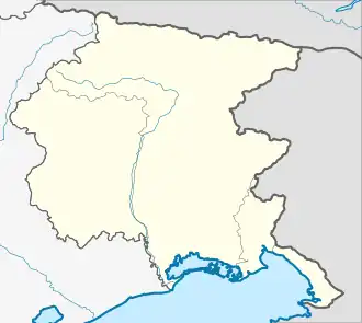 Dogna Dogna (Friuli-Venezia Giulia) | |
| Coordinates: 46°27′N 13°19′E / 46.450°N 13.317°E | |
| Country | Italy |
| Region | Friuli-Venezia Giulia |
| Province | Udine (UD) |
| Area | |
• Total | 70.0 km2 (27.0 sq mi) |
| Elevation | 430 m (1,410 ft) |
| Population (Dec. 2004)[2] | |
• Total | 235 |
| • Density | 3.4/km2 (8.7/sq mi) |
| Demonym | Dognesi |
| Time zone | UTC+1 (CET) |
| • Summer (DST) | UTC+2 (CEST) |
| Postal code | 33010 |
| Dialing code | 0428 |
| Website | Official website |
Dogna (Slovene: Dunja; Friulian: Dogne) is a comune (municipality) in the Regional decentralization entity of Udine in the Italian region of Friuli-Venezia Giulia, located about 100 kilometres (62 mi) northwest of Trieste and about 45 kilometres (28 mi) north of Udine. As of 31 December 2004, it had a population of 235 and an area of 70.0 square kilometres (27.0 sq mi).[3]
Dogna borders the following municipalities: Chiusaforte, Malborghetto Valbruna, Moggio Udinese, Pontebba.
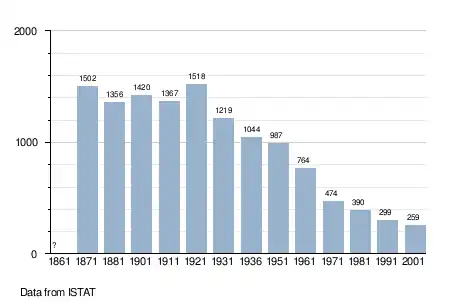
Demographic evolution
References
- ^ "Superficie di Comuni Province e Regioni italiane al 9 ottobre 2011". Italian National Institute of Statistics. Retrieved 16 March 2019.
- ^ "Popolazione Residente al 1° Gennaio 2018". Italian National Institute of Statistics. Retrieved 16 March 2019.
- ^ All demographics and other statistics: Italian statistical institute Istat.