Drhovle
Drhovle | |
|---|---|
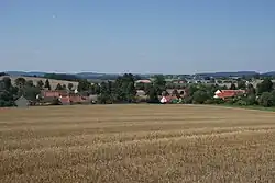 General view | |
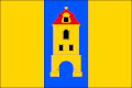 Flag 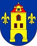 Coat of arms | |
 Drhovle Location in the Czech Republic | |
| Coordinates: 49°20′2″N 14°2′27″E / 49.33389°N 14.04083°E | |
| Country | |
| Region | South Bohemian |
| District | Písek |
| First mentioned | 1323 |
| Area | |
• Total | 23.27 km2 (8.98 sq mi) |
| Elevation | 456 m (1,496 ft) |
| Population (2025-01-01)[1] | |
• Total | 667 |
| • Density | 29/km2 (74/sq mi) |
| Time zone | UTC+1 (CET) |
| • Summer (DST) | UTC+2 (CEST) |
| Postal code | 397 01 |
| Website | www |
Drhovle is a municipality and village in Písek District in the South Bohemian Region of the Czech Republic. It has about 700 inhabitants.
Drhovle lies approximately 8 kilometres (5 mi) north-west of Písek, 51 km (32 mi) north-west of České Budějovice, and 88 km (55 mi) south of Prague.
Administrative division
Drhovle consists of seven municipal parts (in brackets population according to the 2021 census):[2]
- Drhovle Ves (85)
- Drhovle Zámek (115)
- Brloh (67)
- Chlaponice (40)
- Dubí Hora (94)
- Mladotice (103)
- Pamětice (113)
Demographics
| Year | Pop. | ±% |
|---|---|---|
| 1869 | 1,778 | — |
| 1880 | 1,669 | −6.1% |
| 1890 | 1,592 | −4.6% |
| 1900 | 1,580 | −0.8% |
| 1910 | 1,494 | −5.4% |
| 1921 | 1,496 | +0.1% |
| 1930 | 1,396 | −6.7% |
| 1950 | 1,035 | −25.9% |
| 1961 | 1,031 | −0.4% |
| 1970 | 866 | −16.0% |
| 1980 | 753 | −13.0% |
| 1991 | 661 | −12.2% |
| 2001 | 595 | −10.0% |
| 2011 | 554 | −6.9% |
| 2021 | 617 | +11.4% |
| Source: Censuses[3][4] | ||
References
- ^ "Population of Municipalities – 1 January 2025". Czech Statistical Office. 2025-05-16.
- ^ "Public Census 2021 – basic data". Public Database (in Czech). Czech Statistical Office. 2022.
- ^ "Historický lexikon obcí České republiky 1869–2011" (in Czech). Czech Statistical Office. 2015-12-21.
- ^ "Population Census 2021: Population by sex". Public Database. Czech Statistical Office. 2021-03-27.
External links
Wikimedia Commons has media related to Drhovle.