Podolí I
Podolí I | |
|---|---|
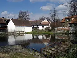 Centre of Podolí I | |
 Flag  Coat of arms | |
 Podolí I Location in the Czech Republic | |
| Coordinates: 49°21′40″N 14°18′43″E / 49.36111°N 14.31194°E | |
| Country | |
| Region | South Bohemian |
| District | Písek |
| First mentioned | 1209 |
| Area | |
• Total | 8.97 km2 (3.46 sq mi) |
| Elevation | 454 m (1,490 ft) |
| Population (2025-01-01)[1] | |
• Total | 361 |
| • Density | 40/km2 (100/sq mi) |
| Time zone | UTC+1 (CET) |
| • Summer (DST) | UTC+2 (CEST) |
| Postal code | 398 43 |
| Website | www |
Podolí I is a municipality and village in Písek District in the South Bohemian Region of the Czech Republic. It has about 400 inhabitants.
Podolí I lies approximately 15 kilometres (9 mi) north-east of Písek, 45 km (28 mi) north of České Budějovice, and 81 km (50 mi) south of Prague.
Administrative division
Podolí I consists of three municipal parts (in brackets population according to the 2021 census):[2]
- Podolí I (245)
- Podolsko (57)
- Rastory (48)
Demographics
| Year | Pop. | ±% |
|---|---|---|
| 1869 | 633 | — |
| 1880 | 674 | +6.5% |
| 1890 | 643 | −4.6% |
| 1900 | 636 | −1.1% |
| 1910 | 555 | −12.7% |
| 1921 | 583 | +5.0% |
| 1930 | 510 | −12.5% |
| 1950 | 396 | −22.4% |
| 1961 | 381 | −3.8% |
| 1970 | 384 | +0.8% |
| 1980 | 404 | +5.2% |
| 1991 | 384 | −5.0% |
| 2001 | 355 | −7.6% |
| 2011 | 355 | +0.0% |
| 2021 | 350 | −1.4% |
| Source: Censuses[3][4] | ||
References
- ^ "Population of Municipalities – 1 January 2025". Czech Statistical Office. 2025-05-16.
- ^ "Public Census 2021 – basic data". Public Database (in Czech). Czech Statistical Office. 2022.
- ^ "Historický lexikon obcí České republiky 1869–2011" (in Czech). Czech Statistical Office. 2015-12-21.
- ^ "Population Census 2021: Population by sex". Public Database. Czech Statistical Office. 2021-03-27.
External links
Wikimedia Commons has media related to Podolí I.