Fanning, Kansas
Fanning, Kansas | |
|---|---|
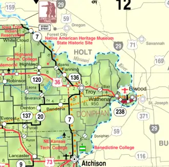 KDOT map of Doniphan County (legend) | |
 Fanning  Fanning | |
| Coordinates: 39°50′05″N 95°09′41″W / 39.83472°N 95.16139°W[1] | |
| Country | United States |
| State | Kansas |
| County | Doniphan |
| Founded | 1870 |
| Elevation | 883 ft (269 m) |
| Time zone | UTC-6 (CST) |
| • Summer (DST) | UTC-5 (CDT) |
| Area code | 785 |
| FIPS code | 20-22975 |
| GNIS ID | 473026 [1] |
Fanning is an unincorporated community in Doniphan County, Kansas, United States.[1] Fanning is located along K-7, 5 miles (8.0 km) northwest of Troy.
History
Fanning got its start in the year 1870, following construction of the Burlington and Missouri River Railroad through that territory.[2]
A post office was opened in Fanning in December 1870 and remained in operation until it was discontinued in July 1933.[3]
References
- ^ a b c d "Fanning, Kansas", Geographic Names Information System, United States Geological Survey, United States Department of the Interior
- ^ Blackmar, Frank Wilson (1912). Kansas: A Cyclopedia of State History, Embracing Events, Institutions, Industries, Counties, Cities, Towns, Prominent Persons, Etc. Standard Publishing Company. pp. 621.
- ^ "Kansas Post Offices, 1828-1961 (archived)". Kansas Historical Society. Archived from the original on October 9, 2013. Retrieved June 8, 2014.
Further reading
External links
- Doniphan County maps: Current, Historic Archived February 24, 2024, at the Wayback Machine, KDOT
Municipalities and communities of Doniphan County, Kansas, United States | ||
|---|---|---|
| Cities |  | |
| CDPs | ||
| Unincorporated communities | ||
| Ghost towns | ||
| Indian reservations | ||
| Townships | ||
| Footnotes | ‡This populated place also has portions in an adjacent county or counties | |