Fotadrevo
Fotadrevo | |
|---|---|
 Fotadrevo Location in Madagascar | |
| Coordinates: 24°3′S 45°1′E / 24.050°S 45.017°E | |
| Country | |
| Region | Atsimo-Andrefana |
| District | Ampanihy |
| Elevation | 493 m (1,617 ft) |
| Population (2001)[2] | |
• Total | 35,000 |
| • Ethnicities | Mahafaly |
| Time zone | UTC3 (EAT) |
| Postal code | 605 |
Fotadrevo is a rural municipality in southwestern Madagascar. It belongs to the district of Ampanihy, which is a part of Atsimo-Andrefana Region. The population of the commune was estimated to be approximately 35,000.[2]
Primary and junior level secondary education are available in town. The majority 60% of the population of the commune are farmers, while an additional 30% receives their livelihood from raising livestock. The most important crop is rice, while other important products are peanuts, cassava and onions. Industry and services provide employment for 1% and 9% of the population, respectively.[2]
Infrastructure
Fotadrevo is presently not connected to the electric grid. Jirama previews to produce electricity locally by the means of generators and solar from August 2023.[3]
Mining
The Molo mine is situated 11.5 km North-north-east of Fotadrevo.[4]
References
- ^ Estimated based on DEM data from Shuttle Radar Topography Mission
- ^ a b c "ILO census data". Cornell University. 2002. Retrieved 2008-03-11.
- ^ Journal TV Plus, 6.June 2023
- ^ Mindat.org
Capital: Toliara | ||
| Ampanihy Ouest (19) - 605 | 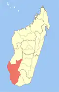 | |
| Ankazoabo - 606 - (10) |
| |
| Benenitra - 610 - (6) |
| |
| Beroroha - 611 - (9) |
| |
| Betioky-Atsimo -612 - (31) |
| |
| Morombe (9) - 618 | ||
| Sakaraha (12) - 620 | ||
| Toliara I (1) | ||
| Toliara II (22) (602) | ||
9 districts; 119 communes | ||