Geča
Geča
Hernádgecse | |
|---|---|
 | |
 Flag | |
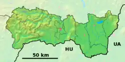 Geča Location of Geča in the Košice Region  Geča Location of Geča in Slovakia | |
| Coordinates: 48°38′N 21°19′E / 48.63°N 21.32°E | |
| Country | |
| Region | |
| District | Košice-okolie District |
| First mentioned | 1255 |
| Area | |
• Total | 5.48 km2 (2.12 sq mi) |
| Elevation | 181 m (594 ft) |
| Population (2021)[3] | |
• Total | 1,883 |
| Time zone | UTC+1 (CET) |
| • Summer (DST) | UTC+2 (CEST) |
| Postal code | 441 3[2] |
| Area code | +421 55[2] |
| Car plate | KS |
| Website | www |
Geča (Hungarian: Hernádgecse) is a village and municipality in Košice-okolie District in the Kosice Region of eastern Slovakia. As of 2022, it has a population of about 1862 people.[4]
History
In historical records the village was first mentioned in 1255.[5]
Geography
The village lies at an altitude of 185 metres and covers an area of 5.481 km2.[5]
Genealogical resources
The records for genealogical research are available at the state archive "Statny Archiv in Kosice, Slovakia"
- Roman Catholic church records (births/marriages/deaths): 1787-1896 (parish B)
- Greek Catholic church records (births/marriages/deaths): 1791-1896 (parish B)
See also
References
- ^ "Hustota obyvateľstva - obce [om7014rr_ukaz: Rozloha (Štvorcový meter)]". www.statistics.sk (in Slovak). Statistical Office of the Slovak Republic. 2022-03-31. Retrieved 2022-03-31.
- ^ a b c "Základná charakteristika". www.statistics.sk (in Slovak). Statistical Office of the Slovak Republic. 2015-04-17. Retrieved 2022-03-31.
- ^ "Počet obyvateľov podľa pohlavia - obce (ročne)". www.statistics.sk (in Slovak). Statistical Office of the Slovak Republic. 2022-03-31. Retrieved 2022-03-31.
- ^ "Geča (Okres Košice - okolie)". Moja obec v štatistikách (in Slovak). Retrieved 24 December 2023.
- ^ a b "Geča". Archived from the original on 18 April 2013. Retrieved 24 December 2023.