Trebejov
Trebejov
Terebő | |
|---|---|
 | |
 Flag | |
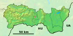 Trebejov Location of Trebejov in the Košice Region  Trebejov Location of Trebejov in Slovakia | |
| Coordinates: 48°50′N 21°14′E / 48.83°N 21.23°E | |
| Country | |
| Region | |
| District | Košice-okolie District |
| First mentioned | 1289 |
| Area | |
• Total | 7.67 km2 (2.96 sq mi) |
| Elevation | 241 m (791 ft) |
| Population (2021)[3] | |
• Total | 207 |
| Time zone | UTC+1 (CET) |
| • Summer (DST) | UTC+2 (CEST) |
| Postal code | 448 1[2] |
| Area code | +421 55[2] |
| Car plate | KS |
| Website | www |
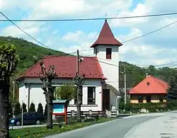
Trebejov (Hungarian: Terebő) is a village and municipality in Košice-okolie District in the Kosice Region of eastern Slovakia. In historical records, the village was first mentioned in 1289.[4] The village lies at an altitude of 240 m, and covers an area of 7.671 km².
References
- ^ "Hustota obyvateľstva - obce [om7014rr_ukaz: Rozloha (Štvorcový meter)]". www.statistics.sk (in Slovak). Statistical Office of the Slovak Republic. 2022-03-31. Retrieved 2022-03-31.
- ^ a b c "Základná charakteristika". www.statistics.sk (in Slovak). Statistical Office of the Slovak Republic. 2015-04-17. Retrieved 2022-03-31.
- ^ "Počet obyvateľov podľa pohlavia - obce (ročne)". www.statistics.sk (in Slovak). Statistical Office of the Slovak Republic. 2022-03-31. Retrieved 2022-03-31.
- ^ "Cassovia.sk ::". www.cassovia.sk. Retrieved 2020-10-18.
External links