Girardville, Quebec
Girardville | |
|---|---|
 | |
 | |
 Girardville Location in Saguenay–Lac-Saint-Jean Quebec | |
| Coordinates: 49°00′N 72°33′W / 49.000°N 72.550°W[1] | |
| Country | |
| Province | |
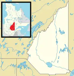
| Region | Saguenay–Lac-Saint-Jean |
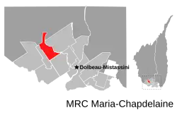
| RCM | Maria-Chapdelaine |
| Settled | 1899 |
| Constituted | November 11, 1921 |
| Government | |
| • Mayor | Jeanne Savard |
| • Federal riding | Lac-Saint-Jean |
| • Prov. riding | Roberval |
| Area | |
• Total | 133.10 km2 (51.39 sq mi) |
| • Land | 124.11 km2 (47.92 sq mi) |
| Population (2021)[3] | |
• Total | 1,018 |
| • Density | 8.2/km2 (21/sq mi) |
| • Pop (2016–21) | |
| • Dwellings | 511 |
| Time zone | UTC−5 (EST) |
| • Summer (DST) | UTC−4 (EDT) |
| Postal code(s) | |
| Area codes | 418 and 581 |
| Climate | Dfb |
| Website | www |
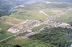
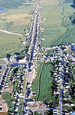
Girardville (French pronunciation: [ʒiʁaʁvil]) is a municipality in the Canadian province of Quebec, located within the regional county municipality of Maria-Chapdelaine. The municipality had a population of 1,018 in the Canada 2021 Census. The municipality is named in honour of Joseph Girard, former federal deputy for Lac-St-Jean County.
Climate
| Climate data for Girardville (Hémon), Quebec: 183 m (600 ft) (1981–2010 normals, extremes 1963–2002) | |||||||||||||
|---|---|---|---|---|---|---|---|---|---|---|---|---|---|
| Month | Jan | Feb | Mar | Apr | May | Jun | Jul | Aug | Sep | Oct | Nov | Dec | Year |
| Record high °C (°F) | 11.0 (51.8) |
12.0 (53.6) |
19.0 (66.2) |
30.0 (86.0) |
33.5 (92.3) |
35.0 (95.0) |
35.0 (95.0) |
37.8 (100.0) |
31.5 (88.7) |
25.5 (77.9) |
18.3 (64.9) |
10.0 (50.0) |
37.8 (100.0) |
| Mean daily maximum °C (°F) | −11.9 (10.6) |
−8.0 (17.6) |
−1.2 (29.8) |
7.5 (45.5) |
16.5 (61.7) |
21.9 (71.4) |
23.8 (74.8) |
22.4 (72.3) |
16.6 (61.9) |
9.1 (48.4) |
0.4 (32.7) |
−7.4 (18.7) |
7.5 (45.4) |
| Daily mean °C (°F) | −19.3 (−2.7) |
−16.2 (2.8) |
−8.7 (16.3) |
1.1 (34.0) |
9.1 (48.4) |
14.4 (57.9) |
16.9 (62.4) |
15.4 (59.7) |
10.4 (50.7) |
4.1 (39.4) |
−4.2 (24.4) |
−13.7 (7.3) |
0.8 (33.4) |
| Mean daily minimum °C (°F) | −26.6 (−15.9) |
−24.4 (−11.9) |
−16.2 (2.8) |
−5.3 (22.5) |
1.6 (34.9) |
6.9 (44.4) |
9.9 (49.8) |
8.4 (47.1) |
4.2 (39.6) |
−1.0 (30.2) |
−8.7 (16.3) |
−20.0 (−4.0) |
−5.9 (21.3) |
| Record low °C (°F) | −49.0 (−56.2) |
−50.6 (−59.1) |
−42.8 (−45.0) |
−32.0 (−25.6) |
−13.9 (7.0) |
−6.5 (20.3) |
−1.7 (28.9) |
−3.3 (26.1) |
−8.3 (17.1) |
−17.8 (0.0) |
−32.0 (−25.6) |
−47.0 (−52.6) |
−50.6 (−59.1) |
| Average precipitation mm (inches) | 72.7 (2.86) |
50.7 (2.00) |
56.2 (2.21) |
67.5 (2.66) |
90.1 (3.55) |
93.6 (3.69) |
122.7 (4.83) |
99.8 (3.93) |
100.9 (3.97) |
76.2 (3.00) |
83.9 (3.30) |
74.8 (2.94) |
989.1 (38.94) |
| Average snowfall cm (inches) | 68.9 (27.1) |
45.2 (17.8) |
37.2 (14.6) |
19.4 (7.6) |
2.6 (1.0) |
0.0 (0.0) |
0.0 (0.0) |
0.0 (0.0) |
0.0 (0.0) |
4.9 (1.9) |
36.5 (14.4) |
65.7 (25.9) |
280.4 (110.3) |
| Average precipitation days (≥ 0.2 mm) | 12.4 | 8.7 | 8.4 | 9.7 | 14.6 | 14.7 | 19.2 | 18.1 | 18.6 | 14.4 | 12.1 | 12.1 | 163 |
| Average snowy days (≥ 0.2 cm) | 12.0 | 8.0 | 6.2 | 2.9 | 0.3 | 0.0 | 0.0 | 0.0 | 0.0 | 0.9 | 6.5 | 11.0 | 47.8 |
| Source: Environment Canada[4] | |||||||||||||
Demographics
Population trend:[5]
- Population in 2021: 1018 (2016 to 2021 population change: 3%)
- Population in 2016: 988
- Population in 2011: 1100
- Population in 2006: 1186
- Population in 2001: 1285
- Population in 1996: 1350
- Population in 1991: 1391
Private dwellings occupied by usual residents: 470 (total dwellings: 511)
Mother tongue:[6]
- English as first language: 0.5%
- French as first language: 99%
- English and French as first language: 0%
- Other as first language: 0.5%
References
- ^ "Banque de noms de lieux du Québec: Reference number 25496". toponymie.gouv.qc.ca (in French). Commission de toponymie du Québec.
- ^ a b Ministère des Affaires municipales, des Régions et de l'Occupation du territoire - Répertoire des municipalités: Girardville Archived 2015-12-12 at the Wayback Machine
- ^ a b "Girardville census profile". 2021 Census data. Statistics Canada. Retrieved 2022-04-13.
- ^ "Hemon, Quebec". Canadian Climate Normals 1981–2010 (in English and French). Environment Canada. Retrieved July 26, 2024.
- ^ Statistics Canada: 1996, 2001, 2006, 2011, 2016, 2021 census
- ^ https://www12.statcan.gc.ca/census-recensement/2016/dp-pd/prof/details/page.cfm?Lang=E&Geo1=CSD&Code1=2492055&Geo2=PR&Code2=24&SearchText=Girardville&SearchType=Begins&SearchPR=01&B1=All&TABID=1&type=1 Canada 2016 Census Community Profiles: Girardville]. Statistics Canada.
External links
![]() Media related to Girardville, Quebec at Wikimedia Commons
Media related to Girardville, Quebec at Wikimedia Commons
Adjacent Municipal Subdivisions | |
|---|---|
| Cities & towns | |
|---|---|
| Municipalities | |
| Parishes | |
| Villages | |
| Unorganized territories | |
| |