Sainte-Élisabeth-de-Proulx
Sainte-Élisabeth-de-Proulx | |
|---|---|
 Church of Sainte-Élisabeth-de-Proulx | |
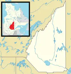 Sainte-Élisabeth-de-Proulx Location in Saguenay–Lac-Saint-Jean Quebec | |
| Coordinates: 48°57′N 72°04′W / 48.950°N 72.067°W | |
| Country | Canada |
| Province | Quebec |
| Region | Saguenay–Lac-Saint-Jean |
| RCM | Maria-Chapdelaine |
| Constituted | October 7, 2024 |
| Government | |
| • Federal riding | Jonquière |
| • Prov. riding | Roberval |
| Time zone | UTC−05:00 (EST) |
| • Summer (DST) | UTC−04:00 (EDT) |
| Area codes | 418 and 581 |
Sainte-Élisabeth-de-Proulx (French pronunciation: [sɛ̃t elizabɛt də pʁu]) is an unorganized territory in the Canadian province of Quebec, located between the Peribonka River on the east and the Mistassibi River on the west created in 2024 by splitting from Passes-Dangereuses.[2]
References
- ^ a b "Ministère des Affaires municipales, des Régions et de l'Occupation du territoire - Répertoire des municipalités". www.quebec.ca.
- ^ "Modifications aux municipalités du Québec Oct 2024" (PDF). statistique.quebec.ca.
Adjacent Municipal Subdivisions | ||||||||||||||||
|---|---|---|---|---|---|---|---|---|---|---|---|---|---|---|---|---|
| ||||||||||||||||
| Cities & towns | |
|---|---|
| Municipalities | |
| Parishes | |
| Villages | |
| Unorganized territories | |
| |