Grýtubakkahreppur
Grýtubakkahreppur | |
|---|---|
 Skyline of Grýtubakkahreppur | |
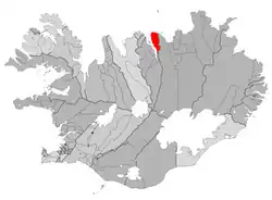 Location of Grýtubakkahreppur | |
 Grýtubakkahreppur | |
| Coordinates: 65°56′56″N 18°11′56″W / 65.9488876°N 18.1988985°W | |
| Country | Iceland |
| Region | Northeastern Region |
| Constituency | Northeast Constituency |
| Government | |
| • Manager | Þröstur Friðfinnsson |
| Area | |
• Total | 432 km2 (167 sq mi) |
| Population | |
• Total | 353 |
| • Density | 0.82/km2 (2.1/sq mi) |
| Postal code(s) | 6602 |
| Municipal number | 610 |
| Website | grenivik |
Grýtubakkahreppur (Icelandic pronunciation: [ˈkriːtʏˌpahkaˌr̥ɛhpʏr̥] ⓘ, regionally also [ˈkriːtʰʏ-]) is a municipality located in northern-central Iceland, in Northeastern Region.
The population is approximately 400. It has a local convenience store, a bank, a preschool and a grade school.
Geography
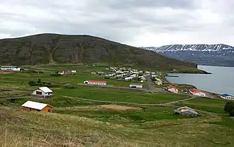
Located on the eastern side of Eyjafjörður, north of Akureyri, next to Dalvík and not too far from Húsavík. Its main settlement is the village Grenivík [ˈkrɛːnɪˌviːk], which is located next to Kaldbakur mountain.[1]
Sports
Local football club Magni Grenivík plays in the third tier of the Iceland football pyramid and play their home games at the Grenivíkurvöllur.
References
External links
- Official website (in Icelandic)