Hangács
Hangács | |
|---|---|
 Coat of arms | |
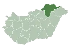
 Hangács Location of Hangács in Hungary | |
| Coordinates: 48°17′24.36″N 20°49′46.34″E / 48.2901000°N 20.8295389°E | |
| Country | Hungary |
| Region | Northern Hungary |
| County | Borsod-Abaúj-Zemplén |
| Subregion | Edelény |
| Rank | Village |
| Area | |
• Total | 22.53 km2 (8.70 sq mi) |
| Population (2009)[2] | |
• Total | 653 |
| • Density | 29/km2 (75/sq mi) |
| Time zone | UTC+1 (CET) |
| • Summer (DST) | UTC+2 (CEST) |
| Postal code | 3795 |
| Area code | +36 46 |
| KSH code | 11226[1] |
| Website | https://www.hangacs.hu/ |
Hangács is a village in Borsod-Abaúj-Zemplén County in northeastern Hungary. As of 2008 it had a population of 645. In 2015 it had a population of 581. It is around 25km North of Edelény. For a long time it was hard to access the village, only being accessible from a side road from the 2617 road. Following Hungary's admittance to the European Union, a road to the village was built.
References
- ^ a b Hangács at the Hungarian Central Statistical Office (Hungarian).
- ^ Hangács at the Hungarian Central Statistical Office (Hungarian). 1 January 2009