Vadna
Vadna | |
|---|---|
Village | |
 Flag  Coat of arms | |
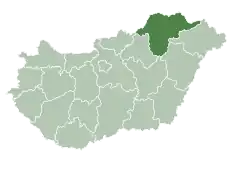
 Vadna Location of Vadna | |
| Coordinates: 48°16′23″N 20°33′10″E / 48.27299°N 20.55273°E | |
| Country | Hungary |
| Region | Northern Hungary |
| County | Borsod-Abaúj-Zemplén |
| District | Kazincbarcika |
| Area | |
• Total | 7.81 km2 (3.02 sq mi) |
| Population (1 January 2024)[1] | |
• Total | 608 |
| • Density | 78/km2 (200/sq mi) |
| Time zone | UTC+1 (CET) |
| • Summer (DST) | UTC+2 (CEST) |
| Postal code | 3636 |
| Area code | (+36) 48 |
| Website | www |
Vadna is a village in Borsod-Abaúj-Zemplén county, Hungary.
Etymology
The name comes from Slavic/Slovak vodná derived from voda (water). Wodna (1237—1242, falsum dated to 1237).[2]
References
- ^ Detailed Gazetteer of Hungary. 23 September 2024 https://www.ksh.hu/apps/hntr.telepules?p_lang=EN&p_id=07223. Retrieved 23 September 2024.
{{cite web}}: Missing or empty|title=(help) - ^ Varsik, Branislav (1977). Osídlenie košickej kotliny III (in Slovak). Bratislava: Slovenská akadémia vied. p. 413.
External links
- Street map Archived 1 October 2007 at the Wayback Machine (in Hungarian)