Horní Lhota (Zlín District)
Horní Lhota | |
|---|---|
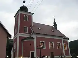 Church of Saint Denis of Paris | |
 Flag  Coat of arms | |
 Horní Lhota Location in the Czech Republic | |
| Coordinates: 49°9′16″N 17°48′16″E / 49.15444°N 17.80444°E | |
| Country | |
| Region | Zlín |
| District | Zlín |
| First mentioned | 1420 |
| Area | |
• Total | 12.65 km2 (4.88 sq mi) |
| Elevation | 340 m (1,120 ft) |
| Population (2025-01-01)[1] | |
• Total | 608 |
| • Density | 48/km2 (120/sq mi) |
| Time zone | UTC+1 (CET) |
| • Summer (DST) | UTC+2 (CEST) |
| Postal code | 763 23 |
| Website | www |
Horní Lhota is a municipality and village in Zlín District in the Zlín Region of the Czech Republic. It has about 600 inhabitants.
Horní Lhota lies approximately 14 kilometres (9 mi) south-east of Zlín and 265 km (165 mi) south-east of Prague.
Demographics
| Year | Pop. | ±% |
|---|---|---|
| 1869 | 387 | — |
| 1880 | 379 | −2.1% |
| 1890 | 378 | −0.3% |
| 1900 | 381 | +0.8% |
| 1910 | 418 | +9.7% |
| 1921 | 441 | +5.5% |
| 1930 | 431 | −2.3% |
| 1950 | 441 | +2.3% |
| 1961 | 506 | +14.7% |
| 1970 | 520 | +2.8% |
| 1980 | 496 | −4.6% |
| 1991 | 500 | +0.8% |
| 2001 | 530 | +6.0% |
| 2011 | 552 | +4.2% |
| 2021 | 565 | +2.4% |
| Source: Censuses[2][3] | ||
References
- ^ "Population of Municipalities – 1 January 2025". Czech Statistical Office. 2025-05-16.
- ^ "Historický lexikon obcí České republiky 1869–2011" (in Czech). Czech Statistical Office. 2015-12-21.
- ^ "Population Census 2021: Population by sex". Public Database. Czech Statistical Office. 2021-03-27.
External links
Wikimedia Commons has media related to Horní Lhota (Zlín District).