Hovtun
40°58′N 43°49′E / 40.967°N 43.817°E
Hovtun
Հովտուն | |
|---|---|
 Սեպ | |
 Hovtun  Hovtun | |
| Coordinates: 40°58′N 43°49′E / 40.967°N 43.817°E | |
| Country | Armenia |
| Province | Shirak |
| Municipality | Amasia |
| Population (2011) | |
• Total | 154[1] |
| Time zone | UTC+4 |
| • Summer (DST) | UTC+5 |
Hovtun (Armenian: Հովտուն) is a village in the Amasia Municipality of the Shirak Province of Armenia. The village was originally inhabited by Azerbaijanis, then Greeks, and now Armenians.[2]
Demographics
| Year | Pop. | ±% p.a. |
|---|---|---|
| 1831 | 27 | — |
| 1897 | 220 | +3.23% |
| 1926 | 352 | +1.63% |
| 1939 | 477 | +2.37% |
| 1959 | 236 | −3.46% |
| 1970 | 207 | −1.18% |
| 1979 | 253 | +2.25% |
| 1989 | 238 | −0.61% |
| 2001 | 190 | −1.86% |
| 2011 | 154 | −2.08% |
| Source: [3] | ||
References
- ^ "Shirak (Armenia): Towns and Villages in Municipalities". www.citypopulation.de. Retrieved 2025-07-17.
- ^ Kiesling, Brady; Kojian, Raffi (2005). Rediscovering Armenia: Guide (2nd ed.). Yerevan: Matit Graphic Design Studio. ISBN 99941-0-121-8.
- ^ Հայաստանի Հանրապետության բնակավայրերի բառարան [Republic of Armenia settlements dictionary] (PDF) (in Armenian). Yerevan: Cadastre Committee of the Republic of Armenia. 2008. Archived from the original (PDF) on 11 March 2018.
- Hovtun at GEOnet Names Server
- Report of the results of the 2001 Armenian Census, Statistical Committee of Armenia
Capital: Gyumri | ||
| Urban settlements | 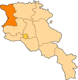 | |
| Akhuryan Municipality | ||
| Amasia Municipality | ||
| Ani Municipality | ||
| Artik Municipality | ||
| Ashotsk Municipality | ||